
图威德角和库兰加塔
特威德海兹(Tweed Heads)和库兰加塔(Coolangatta)是位于新南威尔士州东北部和昆士兰州东南部边界的姊妹城市。库兰加塔位于昆士兰州,是黄金海岸市的一部分。特威德海兹及其邻近郊区是黄金海岸城市区域的一部分,但隶属于特威德郡(Tweed Shire),该郡的首府位于默威伦巴(Murwillumbah)。
了解
[]当您从南部跨越宽阔的特威德河(Tweed River)时,您将继续在新南威尔士州行驶约5公里,然后进入昆士兰州。边界位于河流入海口附近的建成零售区。
|
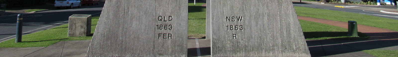
边界在哪里?
新南威尔士州和昆士兰州之间的边界蜿蜒穿过特威德海兹和库兰加塔两镇。由于建筑物、道路和其他结构跨越了边界,因此通常很难确定您身处哪个州。这在夏季尤其重要,因为新南威尔士州实行夏令时,而昆士兰州不实行。如果您从南部抵达库兰加塔机场,您将降落在新南威尔士州,然后滑行至昆士兰州的航站楼。边界实际上是19世纪根据分水岭划定的测量线。当测量员埃文斯(Evans)向东沿着麦克弗森山脉(MacPherson range)行进时,他被指示标记边界并将其终止在危险角(Point Danger),但分水岭在库伦宾(Currumbin)的岬角处,距离北部有些距离。他从库伦宾后面的山丘画了一条直线到当时认为是危险角的地方,因此边界平行于海滩延伸数公里,然后终止于特威德河口以北的岬角。 |
库兰加塔(Coolangatta)的发音重音在倒数第二个音节上,类似于regatta,不同于Talangatta。
- Tweed Heads Visitor Information Centre (Tweed Tourism Inc), 7/1 Wharf Street, Tweed Heads, ☏ +61 7 5536 6737, 1800 674 414 (domestic). Providing tourism information for the Tweed region. Maps, posters and souvenirs. Accommodation, tour and cruise booking service. Open 7 days.


抵达
[]乘飞机
[]- Gold Coast Airport (OOL IATA aka Coolangatta Airport) (in Coolangatta, about 5 km from Tweed Heads). It's a low-cost carrier hub, serviced by AirAsia X, Jetstar, and others. It is not a 24-hr airport and closes at night, so don't plan on spending the night before an early morning flight. It is around 30 minutes drive to Surfers Paradise. There is a shuttle bus connecting the airport to the main Surfside buses route on the Gold Coast Highway between Tweed Heads and Surfers Paradise. Has domestic flights and international flights from New Zealand, Malaysia, and Japan.


乘巴士
[]有巴士从布里斯班(Brisbane)和南部地区发车。从布里斯班到黄金海岸中部的罗宾纳(Robina)的火车服务,有巴士连接到库兰加塔和特威德海兹。
乘汽车
[]从布里斯班经太平洋高速公路(Pacific Motorway)驾车前往,约65分钟车程。您可以在布里斯班机场之后不久下高速,从基拉(Kirra)附近驶入海岸线,然后沿着库兰加塔的海岸公路短途前往特威德海兹。
四处逛逛
[]
乘巴士
[]频繁的Surfside巴士从特威德海兹向北前往库兰加塔和冲浪者天堂。巴士(601至608路)也频繁开往金斯利夫(Kingscliff)、西特威德(West Tweed)和巴纳拉角(Banora Point)。前往默威伦巴(Murwillumbah)的巴士(605路)在工作日每小时一班(周末每两小时一班);这条线路风景尤其优美。603路每天每小时开往博甘达(Bogangar)和波茨维尔(Pottsville),提供前往开发较少且不拥挤的海滩的通道。
乘汽车
[]库兰加塔和特威德海兹很容易从太平洋公路(Pacific Hwy)到达。现在公路绕过了整个区域,使得当地道路拥堵大大缓解。库兰加塔和特威德海兹之间以及库伦宾(Currumbin)的一些小巷相当陡峭。
有关租车公司列表,请参阅黄金海岸文章。
看
[]- Point Danger, Boundary Street (Eastern end). Most prominent headland of the Gold Coast and the point where the New South Wales / Queensland border meets the sea. It features a lighthouse, parklands and a barbeque areas. Excellent views in all directions, including far out to sea where whales and dolphins are often spotted. The whale migration occurs in the winter months, and as the numbers increase they become increasingly visible from the shore. Surfers can also be seen riding the waves off Duranbah Beach and Snapper Rocks. Many Australian and world champion surfriders grew up in these waves. This isn't the point that Cook named Point Danger", that is the point to the south near the small island, now called Fingal Head. The error was made long ago, and the names are now too established to change.
- Fingal Head. Fingal is just across the Tweed River from Tweed Heads, but you must travel south on the Pacific Highway past Sextons Hill and after the motorway crosses the river take the left exit and follow the signs. There are many kilometres of isolated and beautiful beaches to enjoy. It features as its centrepoint, Fingal Head, a volcanic rock headland originally named Point Danger by James Cook in 1770. Subsequently the headland north of the tweed River Mouth was incorrectly named Point Danger, so if you have a fetish for Cook's place names on the East Coast of Australia, this is the Point Danger you must visit. The name Fingal was chosen because of the hexagonal columns of volcanic rock. These used to be a lava finger from the shield volcano, the plug of which is Mount Warning, also named by Cook. Similar rock formations exist in Northern Ireland at Fingal, thus the name. A prominent rock formation off the point is accessed by a small surf affected causeway, and this is named Giants Causeway, also with Northern Irish connections. The surf beach on the northern side is patrolled in summer holidays and weekends. Foreign visitors should remember that inexperience in the surf can lead to trouble, so even if there are others body surfing, it is not a sign that the conditions are benign. In other words, stick to the patrolled beaches. There is a very loyal board surfer fraternity usually finding a wave on the south side of the headland. The camping ground at the main beach offers demountables, van and tent sites. The nearest pub is the Chinderah, on the river on the western side of the highway, once the ferry crossing point for all coastal road traffic. The island off the coast is Cook Island, as it was first mentioned, but not named, by Cook. Dive boats use this for charter dives from Tweed Heads, although you might also make an arranged pick up from the small river marina you pass as you enter Fingal. Camping, or overnight staying is not permitted in the Tweed Shire and this is actively enforced. Also nude bathing is prohibited, and police cars do patrol the beaches, so watch out. There is community concern about undesirable types hanging about, rather than concerns about nudity.
- Tropical Fruit World, Duranbah Road, Duranbah (10 minutes drive south of the airport via Pacific Highway, take the Murwullimbah Exit 40), ☏ +61 2 6677 7222, info@tropicalfruitworld.com.au. 10AM-4PM Qld EST, closed Christmas Day. An educational park where tropical fruit is grown for experiments, viewing and tasting. Home of the Big Avocado. $45 adults, $25 children, $110 family pass.
活动
[]水肺潜水 有几家水肺潜水公司将库克岛作为潜水地点。库克岛是詹姆斯·库克船长于1770年命名危险角和警告山时首次提及的小岛,距离海岸约2公里。这个火山岩礁岛位于无遮蔽水域,意向潜水员应注意,这里并非大堡礁体验,但珊瑚礁提供了有趣的潜水,水中生活着丰富的海龟。
Bushwalking The Tweed Shire encompasses the catchment of the Tweed River, which drains the southern slopes of the MacPherson Range, known as the Border Ranges in NSW. There are many inspiring hikes in these ranges, but most require navigation experience in rain forest, and the correct equipment for the time of year. However there are several opportunities for the visitor to taste the bushwalking opportunities. Mt Warning has been dealt with in the "Get Out" section below, and is highly recommended for the hiker who likes the surety of National Park signs and maintained paths. Mt Cougal is the twin peaked feature evident from the coast, standing in front of the larger mountainous area behind, the Springbrook Plateau. The walk to Mt Cougal is unmarked, but the following simple instructions will get you there from the Tweed Shire. Drive to Tumblegum on the Tweed River, crossing the river to the north side at the bridge over the Tweed just south of the township. Follow the signs to Murwillumbah along Dulguigan Rd until Tomewin Rd, turn right to the north. This road climbs to the border crossing at the watershed at Tomewin, but near the top of the climb take the turn left on Garden of Eden Road. Follow this to the end and the border fence, and park your car. Now on foot, follow the border fence, a combination stock and rabbit exclusion fence, west, leading to the base of the cliffs on East Cougal. There is a rough scramble to the summit of East Cougal, from where views can be had. The scramble across to the top of West Cougal is an option, but remember you are in steep country. Pay attention to where you go, because you have to come back this way to get back to the fence for the return journey. From Tomewin you can drive into the Currumbin valley and then west for a swim at the Currumbin rock pool, a large deep stream fed popular pool. Further up this valley, 1 km from the end of the road is the Currumbin Rock Slide for the brave. Wagawn is a mountain accessed by taking Queensland Road out of Murwillumbah, and turning left into Numinbah Rd, should be well sign posted. Follow on to the Queensland border, and on the other side of the border gate turn hard left on a dirt road and park. The border fence is a sturdy fence on the top of the ridge and so you follow this in a large arc toward to the obvious mountain to the west; this is Wagawn. The fence terminates at the cliffs so then you follow the well worn path to the right which enters the section called the Bushrangers Cave, a large eroded overhang with sometimes a trickle of water dropping from above. To ascend the mountain above, continue on until a cliff break and it is possible to climb up through the trees and rocks. This is slippery and steep. Pay heed to the way you come, because many parties become uncertain of the track on descent, and end up in steeper circumstances than they wish. There may be some tape on the trees that will help. The track contours to the left high above the cave below, ascending all the time until the border ridge is again attained. Continue up this ridge until it flattens out and you are pretty much at the top and on the National Park track system linking Binna Burra Lodge with O'Reilleys Lodge. Nice place for lunch before the return for a total time 3-4 hours plus stops. Now it occurs that backpackers could arrange to be dropped off at the border gate with their gear and continue on to either of the two mentioned lodges, about 11 km further, where camping and accommodation is available, and transport back to the Gold Coast. This would be an interesting way to get a feel for the Lamington National Park. The best activity is the beach. Coolangatta and Rainbow Bay face north. To get the same wave break you have to go to either Byron Bay or Noosa Heads.
购物
[]- 特威德海兹Centro (特威德商场), Wharf & Bay Streets交叉口. 包含小型专卖店以及Target、Coles和Woolworths等大型知名零售商。
- Showcase on the Beach, 72-80 Marine Parade, Coolangatta. 这是一个购物中心,在Marine Parade和Griffith Street都有入口,Showcase on the Beach设有许多餐厅、咖啡馆、一家酒类商店、Aldi超市、服装店、冲浪用品店、艺术品店、医疗中心、电影院以及上层的写字楼。
- Haven Spa & Bathhouse, 5/131 Minjungbal Drive, Tweed Heads South, ☏ +61 7 5513 0855. 10AM-6PM. Haven Spa & Bathhouse comes from the creator of Kiva spa and is an organic day spa. It offers the highest quality spa treatments at affordable prices. The bathhouse consists of a Finnish hot rock sauna, an oxygenated hot spa and a monsoon shower. They use Eminence an organic skin care range from Hungary. You can enjoy a bathhouse visit for only $25 or stay longer and have a treatment. Whatever you choose, your visit at Haven will leave you feeling refreshed and renewed, as if you have been away on holiday. From $25.
餐饮
[]Tweed Heads has a vibrant club scene based on service and sporting clubs, much larger than the shire would normally sustain. The background to these establishments is that for many years poker machines were prohibited in Queensland, but allowable in clubs in New South Wales. Thus clubs proliferated just over the border in Tweed Heads, thriving on holiday traffic from the Gold Coast and on day trippers from Brisbane. Visitors to the shire may be signed in by the doorman, otherwise entry is restricted to members. The clubs all have much the same offer, larges lounges, bars, dining areas and poker machine areas (foreign visitors please note that poker machines are called "pokies") and entertainment. Some quite big stars often turn out at these venues. The big ones are the Tweed Heads Services Club, 100 metres from Queensland, the Tweed Heads Bowls Club, a bit further on, Seagulls Leagues Club on the Terranora Road and Tweed Heads Golf Club in South Tweed Heads. But this information is placed here in the eat category, because these clubs offer exceptional value for money restaurants.
- Coffee Club, Reflection on the Sea Building, Shop 4, 120 Marine Parade, Coolangatta, ☏ +61 7-5599-4755.
饮品
[]住宿
[]- 库兰加塔/基拉海滩青年旅社. 毗邻澳大利亚最好的海滩之一,步行即可到达机场。旅社设有游泳池、烧烤区、游戏室。
- City Lights Motel (City Lights Motel in Tweed Heads), 35 Minjungbal Drive, Tweed Heads South (10 minutes south from Gold Coast Airport), ☏ +61 7 5524 3004. Budget Accommodation in Tweed Heads South, 10 minutes from Gold Coast Airport. 18 rooms with deluxe, budget and family style accommodation - both motel style and self contained accommodation with cooking facilities. City Lights Motel is wheelchair-friendly. $95.
下一站
[]- 莱蒂西亚湾嘴(Letitia Spit)莱蒂西亚路(Letitia Rd)在芬格尔露营地(Fingal camping ground)之后继续向特威德河的南河口延伸。这条长约4到5公里的道路经过一些新旧房屋,这些房屋是当年在这里定居的斐济人的遗迹,他们在此之前曾在甘蔗田做过合同工。该地区有许多他们的后代。这条曾经崎岖的道路继续通往河口,可以走到河道护岸(参见后期文章)和沙石泵送系统。不同时期这里会有不错的冲浪点和宽阔的海滩。岩石护岸也是渔民们喜爱的垂钓点。
- Tweed River This river, named by John Oxley, is the northernmost of the Northern Rivers of NSW. Rising in the Border Ranges, it is navigable inland to the bustling alternative town of Murwillumbah, some 30 km up river. Murwillumbah is worth a visit; it was once a timber town and positioned so to ship the highly valued rain forest timbers down river to be picked up at wharves once at the mouth of the river. High on the south side of the river is the Murwillumbah art gallery in a new well positioned building. It is surprisingly worth a visit; there is also a coffee shop/cafe on site. At Kondong is a sugar mill, the river previously being the transport option for the carriage of cane to the mill. At Tumbulgum is a bridge to the north, which offers an alternative drive to Murwillumbah, and another road that leads over the MacPherson Range to the Currumbin Valley in Queensland. The pub at Tumbulgum is a popular watering hole, and the town now boasts a coffee shop and restaurant. The boat ramp at Tumbulgum makes this spot also a popular spot for water skiers. The river has always been a favorite for fishermen, but for an innocent newcomer to catch a feed would be a minor miracle. House boats are available in the Tweed Heads marina, and there are endless peaceful and beautiful reaches of the river to explore. Dinghies are also available for hire at Boyds Bay inlet and at Fingal Head. The river is full of shoals, so care must be taken of navigation marks and buoys.
- 警告山(Mount Warning)由詹姆斯·库克船长于1770年命名,用来警告水手注意危险角(现在错误地命名为芬格尔角)外的危险礁石。这座1156米高的突出山峰耸立在特威德河谷和海岸线上,并能看到北部麦克弗森山脉的壮丽景色。通过默威伦巴驾车前往,并沿着指示牌向上游特威德河谷行驶。入口公路爬升至约500米处,然后一条经过整修的之字形步道通往山顶。步行到山顶需要大约2小时,最后是需要通过链条攀爬的斜面区域才能到达顶峰。国家公园在山顶建造了一个360度的观景平台,虽然有些突兀,但非常实用。山脚下最近的酒吧在Uki,是警告山酒店。
- Kingscliff This coastal town is at the next headland south of Fingal head, about 6 km further. Until about 10 years ago it was a sleepy campers mecca, but now boasts a vibrant real estate industry, and a busy coffee shop and restaurant strip, and a shopping centre containing a Woolworths. Camping sites are still available right on the beach. The surf is generally on the small side and board surfers are rarely seen out. Cudgeon Creek enters at the point, and offers blue water fisherman relatively easy access to the ocean, weather dependent of course. The mouth of the river is a favorite swimming place for all ages. There are numerous ocean front parks and facilities. The pub is the popular Grand Pacific Hotel. Further south from Kingscliff is the newish Salt real estate development featuring ocean front hotel, restaurants and bar. Further south from there is Casuarina, a newish development designed to have minimal impact on the environment and which boasts many beach houses of original design, and a surfing beach. One of the features of this development was the apparent requirement that no beach front homes were to have a view of the ocean, so from the beach there is no sign of near habitation.
继续向南前往卡巴里塔(Cabarita)、哈斯廷斯角(Hastings Point)和波茨维尔(Pottsville),所有这些都是非常漂亮的海滨小镇,拥有冲浪海滩。可以找到几个露营地。唯一的酒吧是位于博甘加(Bogangar)的卡巴里塔酒店(Cabarita Hotel)。
| 巴利纳 ← 拜伦湾 ← | S M1 N | → 黄金海岸 → 布里斯班 |