
骑行西撒哈拉
西撒哈拉自行车路线从摩洛哥的盖尔明出发,经毛里塔尼亚,最终到达塞内加尔的圣路易。全程2100 公里(1,300 英里)穿越西撒哈拉,沿途经过撒哈拉沙漠最西端(濒临大海),同时避开撒拉维阿拉伯民主共和国(SADR)控制的有争议地区。

了解
[]从摩洛哥到塞内加尔的路段均为沥青路。在摩洛哥-毛里塔尼亚边境附近有几公里的松软斜坡(截至2006年)。补给点最晚每150 公里(93 英里),相当于2-3天的路程。这条路线是骑自行车从北非穿越到撒哈拉以南国家的最简单方式(截至2006年)。
地理
[]西撒哈拉在地理上分为北部和南部。北部地区,从布久杜尔角开始,以平坦的砾石和沙漠(哈马达)为主。地形从海岸向内陆逐渐升高,高度约400米。南部地区几乎完全平坦,有孤立的沙丘(erg),在几乎没有植被的均匀背景下只有少量变化。
草地和灌木丛以及金合欢树标志着从沙漠草原向南毛里塔尼亚的稀树草原的过渡。
在这里可以找到适应干旱栖息地的动物,例如蝎子、蛇、贾库鲁斯属(Jaculus)的跳鼠和矛尾蜥。在几内亚湾沿岸的洞穴中,尤其是在毛里塔尼亚努瓦迪布附近的白角(Cabo Blanco)半岛,生活着濒危的地中海僧海豹的最大种群。
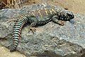 矛尾蜥(Uromastycinae)
 肥尾蝎(Androctonus australis)
 Puff adder (Bitis arietans)


_juvenile_(16156642643).jpg)
气候
[]撒哈拉是一个“旋转沙漠”,这是由持续的、干热的东北信风造成的。即使在航海时代,信风也是强大的牵引力。骑行时,风会不断将你推向南方。它还在近地面携带大量尘土和沙子。
特别是在春季和秋季,强烈的低气压区可以将撒哈拉空气吸过地中海。干燥、炎热的南-东南风(西洛可风)由此形成。由于大量的沙尘,空气会变成黄红色。强烈的逆风会使向南骑行变得困难,并很快让你陷入不愉快的境地。
在努瓦迪布以北沿海地区,由于大西洋的调节作用,气温温和。寒冷的洋流带来凉爽,但也导致沿海地区出现浓雾。新年伊始,气温为20 °C(68 °F),九月和十月气温可升至30 °C(86 °F)。
在努瓦迪布以南沿海地区和塞内加尔河沿线地区,新年伊始气温为20–24 °C(68–75 °F),七月可升至30–34 °C(86–93 °F)。尤其是在南部,湿度明显更高,七月至十月有雨季,总降水量为400 毫米(16 英寸)。
| 1月 | 2月 | 3月 | 4月 | 五月 | 六月 | 七月 | 八月 | 九月 | 10月 | 十一月 | 十二月 | |
|---|---|---|---|---|---|---|---|---|---|---|---|---|
| 平均最高温度 | 20.9 | 22.7 | 23.7 | 23.3 | 24 | 24.8 | 25.7 | 26.5 | 27.4 | 26.6 | 25.1 | 22.5 |
| 平均最低温度 | 13.3 | 13.8 | 14.7 | 14.9 | 15.8 | 16.7 | 17.5 | 18.3 | 18.8 | 18 | 16.6 | 14.5 |
| 平均降水量 | 2 | 3 | 1 | 0 | 0 | 0 | 1 | 2 | 11 | 6 | 3 | 10 |
| 1月 | 2月 | 3月 | 4月 | 五月 | 六月 | 七月 | 八月 | 九月 | 10月 | 十一月 | 十二月 | |
|---|---|---|---|---|---|---|---|---|---|---|---|---|
| 平均最高温度 | 28,8 | 30,4 | 32,5 | 32,8 | 34 | 33,3 | 31,7 | 32,1 | 34,1 | 34,9 | 32,7 | 29,2 |
| 平均最低温度 | 12,7 | 14,3 | 16,7 | 17,8 | 19,6 | 21,8 | 23,4 | 24,1 | 24,3 | 21,8 | 18 | 14 |
| 平均降水量 | 0 | 2 | 2 | 0 | 0 | 0 | 14 | 37 | 28 | 7 | 1 | 7 |
| 1月 | 2月 | 3月 | 4月 | 五月 | 六月 | 七月 | 八月 | 九月 | 10月 | 十一月 | 十二月 | |
|---|---|---|---|---|---|---|---|---|---|---|---|---|
| 平均最高温度 | 30 | 32.1 | 33.6 | 33.9 | 33.9 | 33.8 | 32.4 | 32.8 | 33.6 | 35 | 33.6 | 30.7 |
| 平均最低温度 | 15.4 | 16.1 | 17.5 | 18.2 | 19.6 | 22.1 | 23.6 | 24.3 | 24.3 | 22.6 | 19.3 | 16 |
| 平均降水量 | 1.6 | 1.3 | 0.4 | 0 | 0.4 | 7.6 | 42.4 | 89.7 | 84.9 | 24 | 0.9 | 1.3 |
行程时间和距离
[]原则上,西撒哈拉全年都适合骑行。降雨稀少,雾主要发生在沿海地区。靠近海洋的气温相对温和。风主要从北向南吹,只有在春季和秋季才需要考虑西洛可风带来的逆风。冬季月分气温最凉爽,信风稳定,是旅行的最佳时机。
由于信风,每天骑行80 公里(50 英里)是现实可行的。从盖尔明到圣路易大约需要30天,此外还需要在较大的城市停留以及过境的时间。
准备
[]路况可能在沿途发生巨大变化。定居点可能迁移,道路可能因流沙而无法通行。互联网或书籍上的许多信息都refer to the route before 2005,那时道路尚未开发。当时许多路段必须在沙坡上穿越。因此,请务必核实您获得的信息是否最新。
因此,出发前需要进行准确的搜索。当地人以及其他旅行者都是宝贵的资源。
保持健康
[]在沙漠中旅行,水无疑是第一位的考虑因素。每人每天的饮用水消耗量约为5升。对于长途内陆旅行,在极端温度下,可能需要6升甚至更多。这还不包括烹饪用水。
最好避免正午的酷热,选择清晨和下午骑行。在大量出汗导致液体流失的情况下,也应补充盐分流失。世界卫生组织建议,每升水加入一茶匙盐和6茶匙糖。然而,过多的盐或糖会加剧脱水。补水项目建议每升水加入半茶匙盐和6茶匙糖。与普遍看法相反,人体无法适应缺水。
烹饪
[]通过使用节水型食物可以减少烹饪用水量。烹饪蒸粗麦粉需要一杯水,煮米饭则需要两倍的水。
在西撒哈拉地区,燃气罐的供应稀少。在每个主要城镇都可以买到汽油燃料。
自行车骑行
[]首选车型是旅行自行车。28英寸的轮胎可以让你在沥青路上快速行驶,同时也能应对沙坡。最好选择钢架自行车,因为如果需要维修,钢焊工具比铝焊工具更常见。
沙子和灰尘像砂纸一样磨损齿轮,链条在应力下会拉伸。为了延长寿命,可以携带两到三条链条,每800–1000 公里(500–620 英里)更换一次。这意味着你可以达到10,000 公里(6,200 英里)的行驶距离。之后,你应该更换整个传动系统。
抵达
[]盖尔明是沙漠前的最后一个城镇,也是自行车之旅的起点;请查看其页面了解如何前往。
去
[]
盖尔明(阿拉伯语:كلميم,也称Goulimine 或 Guelmin)是一个拥有约12,000居民的省会城市,位于盖尔明-乌德努恩省。该市中心是Bir Anzarane。在这里您可以找到 Banque Populaire(带自动柜员机)和 邮局。 公交车站位于广场以北,沿着Blvd Moulay Rachid。
从盖尔明到坦坦(130 公里(81 英里))
[]离开盖尔明,沿着Avenue 3 Mars向西南方向行驶。经过盖尔明清真寺后,您将穿过城门。
- 穿越西耶德河(Oued Siyad).


- 蓝色小屋咖啡馆(Café Blue House) (盖尔明以西25 公里(16 英里))。
- 通往Ait Yassine和Aferkat的岔路口.
- 公交车站,通往Labyar的岔路口 (阿拉伯语:البيار) (盖尔明以西44 公里(27 英里))。
- 简易餐厅 (盖尔明以西50 公里(31 英里))。
- Rass Oumlil 村庄,内有餐厅和商店 (盖尔明以西70 公里(43 英里))。
- 观景点 (盖尔明以西88 公里(55 英里))。
- 穿越德拉河(Oued Draa). ,在经过长途跋涉从扎戈拉出发后,在距离这里仅几公里外向西汇入大西洋。
坦坦
[] 坦坦(阿拉伯语:طانطان,也称 al-Hamra,意为“红色”),人口7万,是盖尔明-乌德努恩地区同名省的首府。该市位于主街Ave Hassan II以南,在这条街上您可以找到 邮局和银行 BMCE,旁边是Shell加油站。第二条主干道是Ave Mohammed V,它穿过城市向南。那里有 Banque Populaire和 公交总站(Gare Routiére),位于Ave Mohammed V南部的Place de la Marche Verte。那里有 坦坦机场 ![]() Plage Blanche 机场(TTA IATA)距离 N1 公路以西8 公里(5.0 英里)。由皇家航空摩洛哥(Royal Air Maroc)提供服务,连接坦坦与卡萨布兰卡和盖尔明。
Plage Blanche 机场(TTA IATA)距离 N1 公路以西8 公里(5.0 英里)。由皇家航空摩洛哥(Royal Air Maroc)提供服务,连接坦坦与卡萨布兰卡和盖尔明。
从坦坦到塔法亚(213 公里(132 英里))
[]
如果您从坦坦向西离开,沿着N1行驶,在6 公里(3.7 英里)后会到达机场的岔路口。再往前一公里,R101向左转,通往斯马拉(阿拉伯语:السمارة),距离240 公里(150 英里),在南部。不久之后,右侧的一条小路通往大西洋,距离35 公里(22 英里),从德拉河(Oued Drâa)流出。25 公里(16 英里)到达坦坦,您可以到达 埃尔瓦蒂亚(El Ouatia) ![]() (阿拉伯语:الوطية,也称Tan Tan Plage)。海滩上有看管的停车场
(阿拉伯语:الوطية,也称Tan Tan Plage)。海滩上有看管的停车场
埃尔瓦蒂亚
[]埃尔瓦蒂亚,拥有6500名居民,是摩洛哥最大的渔港之一。这座城市越来越受冲浪者的欢迎,并提供许多酒店。进入城市时,您会经过一个环岛,N1公路从那里向南转。直行进入城市。北边的道路通往Oued Drâa的河口,距离30 公里(19 英里),汇入大西洋。环岛旁边是 韩国屋酒店(Hotel Korea House) (+212 641-431661).
- 坦坦大西洋露营地(Camping Atlantique Tantan).
- 金沙营地(Camp Sables d'Or).
- [死链] equinox露营地(Camping Equinox Tan Tan).
- Essadia Riad(Riad Essadia).
- Hotel La Belle Vue, ☏ +212 662021619, labellevuehotel@gmail.com.
- Café Asfi.
- Restaurant Bergach.
The N1 follows its way south to Akhfenir , very close to the imposing cliff. After about 35 km (22 mi) you cross the Oued Chbika. Climbing up the Wadi, you hit a checkpoint with supply possibilities.
- Oued crossing.
- Oued crossing (70 km (43 mi) past El-Ouatia).
- Devil's hole (French: Gouffre d'Akhfenir or Trou du diable}). . A hole about 25 meters in diameter and 30 meters deep

- Akhfenir (about 90 km (56 mi) post Ouatia).


阿赫芬尼尔
[]South of Akhfenir is one of the largest wind parks in Africa with 131 wind turbines on an area of over 8,900 hectares. A piste leads from Akhfenir to the wind farm, 20 km (12 mi) away, that was listed in the Jeune Afrique magazine as one of the ten most outstanding projects in Africa.
- Hotel Restaurant Atlas.
- Hotel Sahara Beach.
- Pâtisserie Oumaïma.
- Gas station.
- [dead link] Hôtel La Corniche, ☏ +212 661-224250.
- [formerly dead link] La Courbine d'argent.
From Akhfenir the coast becomes flatter again. After approximately 10 km (6.2 mi) the N1 turns off the coast and runs in an arc around the Khenifiss National Park ![]() (Arabic: المنتزه الوطني اخنيفيس, French: Parc National de Khenifiss).
(Arabic: المنتزه الوطني اخنيفيس, French: Parc National de Khenifiss).
Khenifiss National Park
[]The Khenifiss National Park was established in 2006, from the natural reserve of the time, and covers 1,850 km2 (710 sq mi). The park was listed as a UNESCO World Natural Heritage Site in 1998. The park is located on the largest lagoon on the Moroccan coast. Ruddy shelducks (Tadorna ferruginea), marbled ducks (Marmaronetta angustirostris) and Audouin's gulls (Ichthyaetus audouinii) breed here. The mainland is characterized by sabkhas, shallow basins, which are only temporarily watered. Cuvier's gazelles (Gazella cuvieri) were also seen here. In Akhfenir there are numerous guides for tours to the national park. For photo excursions see Rosa Frei Photography, Ouarzazate, rosa@rosafrei.com..
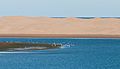 Sand dunes in the national park
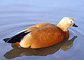 Ruddy shelduck
 Marbled duck
 Audouin's gull
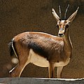 Cuvier's gazelle


After the national park, the N1 meets the coast again. You pass, about 163 km (101 mi) to Ouatia, a small café without WC on the coast and a wreck on the beach.
After 35 km (22 mi) you reach a petrol station at the crossing before Tarfaya. The N1 turns south towards El Aaiún. If you follow the road straight, you reach Tarfaya (Arabic: طرفاية) after 5 km (3.1 mi). Worth seeing the museum on the post flights and Fort Jubly. There is a banc with ATM in town.
Tarfaya
[]

Tarfaya is a small town with a population of more than 8,000 at Cape Juby in the Laâyoune-Sakia El Hamra region. The city is the administrative center of the province of the same name.
The main road through the city is the Ave Ahmed Haidar. In the west you can see the Banque Populaire. On the beach is a monument, in the form of a green plane, for the post flights. Among other things, the writer and pilot Antoine de Saint-Exupéry was stationed here. There is also the Museum Antoine de St Exupery, which is 1 km (0.62 mi) from the coast. One kilometer off the coast are the ruins of the fortress Casa Mar, built by the English in the 1880s. At the beginning of 2008, a ferry service between Tarfaya and Puerto del Rosario on Fuerteventura was opened. This gave Tarfaya a modest economic upturn until the car ferry Assalama leaked in the port of Tarfaya in April 2008 and stranded in the shallow waters where it is still today.
- Hotel Casamar, ☏ +212 5288-95326.
- Hotel Canalina, Ave Mohamed V (next to the Centre de Santé), ☏ +212 641 785 521.
- Cafe Boufous, Ave Ahmed Haidar.
- Attijariwafa bank, Rue Mejjat.
- Pharmacie de Place Saint Exupery, Ave Qaied Baba Ahmed Oueld Youssef.
- Post.
- Snack Restaurant Le9 Delice.
- Marché municipial.
From Tarfaya to El Aaiún (104 km (65 mi))
[]Leaving the city south, you reach a roundabout. The road straight to the south leads back to the N1. On the right a road branches off, which follows the coast to Foum ed Oued (state unknown). After 30 km (19 mi) on the N1 you reach Tah, a small town with cafe, motel and fuel. In the center is a monument for the Green March. 45 公里 (28 英里) past Tarfaya, you pass the turn-off for Daoura (Dawra). After 100 公里 (62 英里) you reach El Aaiún.
El Aaiún
[]

El Aaiún (Arabic: العيون, also Laâyoune) is the largest city in the territory administered by Morocco and the capital of the Moroccan administrative region Laâyoune-Sakia El Hamra.
Most banks, hotels and the post office are located on Blvd Hassan II or Blvd de Mekka. The most important square of the city is the Place du Mechouar.
El Aaiun Hassan I Airport (ICAO: GSAI / GMML) is 2 公里 (1.2 英里) southwest of the N1. It is most often fueled by Royal Air Maroc and Canarian Binter Canarias. The destinations are spread over three countries: Las Palmas (Spain), Agadir, Casablanca, Ad Dakhla and Rabat (Morocco) and Paris-Orly (France).
- 购物
- Banque Populaire, Place Dchira.
- BMCE, Place Dchira.
- BMCE, Place Hassan II.
- Royal Air Maroc, Place Dchira.
- Ensemble Artisanale, Blvd de Mekka.
- 看
- Spanish Cathedrale Franz von Assisi, Ave Hassan II. situated in a nice parc
- Souq Djal. the livelist part of town and has the best restaurants
- Moulay Abdel Aziz Mosque, Blvd Moulay Youssef.
- Smara (Arabic: السمارة), capital of the province Es Semara is accessible via the N5. It is 240 公里 (150 英里) into the interior in an almost vegetationless solid stone and sand desert.
From El Aaiún to Boujdour (193 公里 (120 英里))
[]The Ave Mohammed V crosses the N1 at Place du Mechouar, which leads west from the city. Past the airport it turns 13 公里 (8.1 英里) after the Place du Mechouar sharp south to El Marsa. At the bend, the road branches off to Foum el Oued, which is reached after a further 6 公里 (3.7 英里).
Foum el Oued
[]Foum el Oued (Arabic: فم الواد), also known as the Riviera of the Sahara is particularly popular among the locals.
- Camping Nil. ,clean, cold water only, restaurant only in summer
From Foum el Oued it is 10 公里 (6.2 英里) across the coastal road Ave Ennahda to El Marsa ![]()
El Marsa
[]El Marsa (Arabic: المرسى, also Laâyoune Plage) with about 10,000 inhabitants is the last city to Boujdour, 160 公里 (99 英里) further south. There are some simple cafes and shops.
- Café el Puerto.
- Hotel Marsa, Ave Hassan II.
Shortly after the southern end of the station, crossing the N1 is the world's longest conveyor belt. It transports the phosphate from the mining town of Bou Craa (Arabic: أبوكراع) to the port of loading at El Marsa.
- turn-off for Plage Kerouma (22 km towards El Marsa). with restaurant at the beach
- Lamsid (Arabic: لمسيد) (82 km nach El Marsa). , fuel station with restaurant
80 km past Lamsid is Boujdour. ![]()
![]()
![]()
![]()
![]()
布支杜尔
[]Boujdour (Arabic: بوجدور) is the small city in the province of Laayoune-Sakia El Hamra at Cape Bojador (Arabic: رأس بوجادور, French: Cape Boujdour), with 45,000 inhabitants. It forms the western foothills of the mountain range Jebel el Aswad in the Sahara and was considered in the Middle Ages as the western end of the world (finis terrae). Here you will find the highest sand dunes (Erg), up to 130 m, in the mostly flat coastal region of the Hammada.
Along the N1, which passes through the city as Ave Hassan II, are the most important shops, restaurants and hotels.
- CTM.
- fuel station.
- Post.
- Marché.
- Taxi Station.
- bus station (Gare Routiére).
- Café Marina.
- Hôtel Al Qods.
- Hotel Manarat, hotelmanaratboujdour@gmail.com.
从布久多尔到阿尤恩 (345 公里)
[]- 两处沉船 (布久多尔以西18公里).
- 沉船.
- 咖啡馆 (布久多尔以西140公里).
- Sahara加油站 (布久多尔以西148公里).
- Karaa河谷 (阿拉伯语:واد لكراع, Echtoucan) (布久多尔以西180公里).
- N'Tireft (阿拉伯语:نتيرفت).
- 未知 (布久多尔以西280公里,距离达喀拉60公里).
- 达喀拉-阿尔古布交叉口.
- 非官方露营地 (达喀拉转弯处10公里).
达喀拉
[]
- 达喀拉 是西撒哈拉最南端的城市,也是《达喀拉-乌耶德·代希布》地区的首都。
达喀拉坐落在一片长38公里、宽4公里的平原上。这片平原向西南延伸,与海岸平行,环抱着《黄金河》湾。附近的大陆和半岛由几乎没有植被的沙地和悬崖(reg)组成。半岛的北部海岸面向大海,位于几公里长的沙滩之间,但由于距离摩洛哥的旅游胜地太远,尚未对外开放。城市沿着半岛的东侧延伸,《穆罕默德五世大道》是海滨长廊。向北,与主商业街《瓦拉埃大道》平行。南部,商业区环绕着大清真寺。达喀拉机场每周有几次从卡萨布兰卡出发的航班。
- 四处逛逛
- 大出租车.
- 景点与活动
- 圣母卡门教堂.
- 购物
- 大清真寺.
- CTM巴士.
- BMCE银行.
- 人民银行.
- 餐饮
- 市政室内市场, Boulevard Al Masjid.
- 面包店.
- Errihimi超市.
- Aït Oubaha超市, Rue Oued Tansift.
- Assalam面包房, Rue Oued Tansift.
- Oued Eddahab咖啡馆.
- 撒马尔罕餐厅, Blvd Mohammed V.
- 住宿
- [失效链接] Erraha酒店.
- Sahara Regency, ☏ +212 5289-31666.
- [失效链接] Imperial Playa酒店, Mohammed V大道, ☏ +212 5288-92212.
从达赫拉到格尔格拉特(367公里)
[]- El Argoub (阿拉伯语:العرڭوب) (达赫拉-阿尔吉鲁布口岸以南40公里).
- Imlili (阿拉伯语:إمليلي) (El Argoub以南45公里).
- Tankstelle Chica (El Argoub以南50公里).
- Barbas (阿拉伯语:بئر كندوز) (El Argoub以南210公里).
- 岩石地貌 (Barbas以南30公里).
- 雷达站的发射塔 (Barbas以南50公里).
- 岩石地貌 (在格尔格拉特附近).
- Guerguerat (阿拉伯语:ڭرڭورات مغربية) (Barbas以南80公里).
摩洛哥-毛里塔尼亚边境
[]- 海关办事处 (格尔格拉特以南7公里).
- Bir Guendouz.
从边境到诺瓦迪布(60公里)
[]- 经过铁矿线和诺瓦迪布-诺瓦克肖特交叉口 (格尔格拉特以南20公里,到诺瓦迪布40公里,到布兰努瓦尔40公里,到诺瓦克肖特430公里).
努瓦迪布
[]
诺瓦迪布位于延展40公里至大西洋的Ras Nouadhibou半岛受保护的东侧,与诺瓦迪布湾(原称Lévrier湾)接壤。北部是人口最多的Numerowat区,分为六个Robinet(法语意为水道)。中部,在半月形Cansado湾的北端,是商业区(简称Ville),位于笔直的主干道Médian大道和与之平行的Maritim大道上,东侧,与之平行的是银行、兑换处、警察局和商店。镇中心以南八公里是Cansado(西班牙语:疲倦)区。Cansado以北不远处,有一条五公里长的道路向西通往La Gouira的遗址,这是一个前西班牙贸易中心。半岛的南端已被宣布为国家公园,那里除了毛里塔尼亚士兵和 灯塔,一些稀有的地中海僧海豹仍然在这里出没。 沉船. ![]()
![]()
![]()
诺瓦迪布有一个国际机场(NDB IATA)。有定期航班飞往诺瓦克肖特,以及不定期航班飞往大加那利岛机场。
- 购物
- 市场.
- 银行 (BCM).
- 银行 (BMCI).
- 吃喝
- Quijote餐厅.
- 住宿
- La Chinguetti旅馆, Numerowat, 1ère Robinet, Bd Median.
- Al Jazeera酒店, Maritim大道.
- Sahel酒店.
- Prestige酒店.
- Baie de Levrier露营地, Median大道 (在警察局对面).
- 应对
- 国家安全局 (警察), Median大道.
- 摩洛哥领事馆.
- 连接
- 邮局.
从诺瓦迪布到诺瓦克肖特(436公里)
[]纳尔金海角国家公园
[]该国家公园 [formerly dead link] 位于毛里塔尼亚大西洋沿岸,介于诺瓦克肖特和诺瓦迪布之间,建于1976年。自1989年起,它被列为联合国教科文组织世界遗产。
它包括位于毛里塔尼亚海岸的阿金沙洲,其浅滩延伸至大西洋30海里。沙洲被认为是西非海岸最危险的地方之一。船只通常会远离这一危险的海岸段。此外, 阿金岛北部以及几个较小的岛屿,如两个Kiaone岛, 西部Kiaone岛以及 东Kiaone岛南部。
该公园是褐鹭最重要的越冬地之一。此外,还有许多群居繁殖的鸟类,如火烈鸟、琵鹭、白鹈鹕、猛禽、国王和老虎(此处英文原文有误,疑为“王鹫”和“虎头海雕”等猛禽的错误翻译),以及细嘴鸥。
 中杓鹬 (Numenius phaeopus)
 大红鹳 (Phoenicopterus roseus)
 白琵鹭 (Platalea leucorodia)
 斑嘴鹈鹕 (Pelecanus onocrotalus)
 褐头鸥 (Hydroprogne caspia)
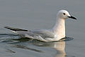 白眼海鸥 (Chroicocephalus genei)


- 通往布·拉努阿尔村的分岔口 (距诺阿迪布湾80公里)。
- 加油站(仅柴油) (距通往布·拉努阿尔的分岔口2公里)。
- 旅馆 (距布·拉努阿尔45公里)。
- 成片树林 (距布·拉努阿尔65公里)。
- 未完工的加油站 (距布·拉努阿尔70公里)。
- 带旅馆和杂货店的帐篷 (距布·拉努阿尔95公里)。
- 带木板房、咖啡馆、旅馆的帐篷 (距布·拉努阿尔160公里)。
- 帐篷,餐厅 (距布·拉努阿尔190公里)。
- 板房 (距布·拉努阿尔275公里)。
- 板房定居点 (距布·拉努阿尔290公里)。
- 通往莱姆西德的分岔口 (距布·拉努阿尔320公里)。
- 右转小路通往贝拉克哈尔渔村 (距布·拉努阿尔340公里)。
- 检查站。最后25公里是穿越垃圾场的四车道公路 (距布·拉努阿尔365公里)。
努瓦克肖特
[]
努瓦克肖特 (阿拉伯语:نواكشوط), 距离布·拉努阿尔390公里(240英里),人口96000,是毛里塔尼亚的首都。
主要的交通路线阿维·贾马尔·阿卜杜勒·纳赛尔大道(Ave Gamal Abdel Nasser)东西贯穿努瓦克肖特,并连接港口,港口在城西6公里(3.7英里)处。市中心有第二条主要道路戴高乐将军大道(Ave du Général de Gaulle)与之交叉,该路南北贯穿城市。交叉点处是城中最高的建筑,一座十层高的 “Al-Khaima”酒店和会议中心(阿拉伯语“帐篷”)。在戴高乐将军大道的北部是商业和大使馆区。城市的其余部分由平坦未铺砌的道路构成。
信息
[]- [死链] 奥地利名誉领事馆, 10, Rue Mamadou Konaté, Al Khaima City Center, 5. Stock (在沙特清真寺旁),☏ +222 4525 5131, consulautrichemauritanie@yahoo.com。
- 主邮局, 阿维·贾马尔·阿卜杜勒·纳赛尔大道(Ave Gamal Abdel Nasser)。
- 毛里塔尼亚中央银行 (BMCI), 阿维·贾马尔·阿卜杜勒·纳赛尔大道(Ave Gamal Abdel Nasser)。
- 国家医院 (Centre Hospitalier Nationale Sabah), 阿维·贾马尔·阿卜杜勒·纳赛尔大道(Ave Gamal Abdel Nassar)。
看
[]- 。 一座大型白色清真寺,屋顶有十个圆顶
- 大清真寺 (Mosquée Saudique)。
- 总统府.
- 国家博物馆。 考古发现和毛里塔尼亚民间艺术
- 。
购物
[]- 首都市场.
- 第五市场.
住宿
[]- 游牧者旅馆, Rue Aliouine Ben Ebi Taleb。
- Monotel酒店, Rue Abdoubekr Seddigh。
- 阿德拉尔酒店, Rue Samba Thiedel M'baye (在市场东南)。
从努瓦克肖特到罗索(205公里)
[]罗索
[] 罗索 ![]() (阿拉伯语:روصو),是毛里塔尼亚第三大城市(2000年数据),人口近5万。基础设施良好。主干道直接穿过村庄通往港口。市中心位于主干道的东侧。
(阿拉伯语:روصو),是毛里塔尼亚第三大城市(2000年数据),人口近5万。基础设施良好。主干道直接穿过村庄通往港口。市中心位于主干道的东侧。
- 阿拉斯玛酒店 (在北入口处)。
- 教堂。,可能是毛里塔尼亚最古老的教堂。
毛里塔尼亚—塞内加尔边境
[]随着法国独立,毛里塔尼亚和塞内加尔之间的边界沿塞内加尔河划定,罗索也被分割。在毛里塔尼亚一侧,税务官员总是试图以虚假签证和盖章处理费为由索要罚款。此外,渡过塞内加尔河的渡轮价格是可以商议的。最好花更多时间冷静且有创意地讨论论据。总的来说,在这里,作为骑行者,你被敲诈的可能性比开车的人要小。
从边境到圣路易斯(98公里)
[]边境小镇 罗索(塞内加尔)约有1万居民。唯一可能的住宿地点是 瓦洛旅馆 位于主干道港口附近。沿着主干道再往前走一点是 巴士总站.
前往理查德·托尔(Richard Toll)的旅程
[]距离罗索6公里,在岔路口向左转,前往 Richard Toll ![]() ,再往里走 13 公里。理查德托尔(Richard Toll)有约 70,000 名居民,主要以糖料的加工而闻名。
,再往里走 13 公里。理查德托尔(Richard Toll)有约 70,000 名居民,主要以糖料的加工而闻名。
- Ross Béthio (48公里,经过 Rosso)。 拥有 11,000 名居民,是塞内加尔的第一个城镇。
- Tilène.
- Ndiongo.
- Lampsar.
圣路易斯
[].JPG)
圣路易斯,自 2000 年以来被列为联合国教科文组织世界文化遗产,约有 176,000 名居民。城市中心位于恩达尔岛(Ile de N'Dar)上,该岛通过 500 米长的法伊德海布桥(Pont Faidherbe)与大陆相连。穿过另一座桥——穆斯塔法·马利克·盖伊桥(Pont Mustapha Malick Gaye),即可到达巴巴里海角国家公园(Langue de Barbarie National Park)。
大陆
[]- 主火车站。
恩达尔岛
[]- 邮局.
- 旅游信息。
- 大教堂。
- 塞内加尔国际商业银行, Rue Blanchot。
- L'Atlantide青年旅舍, Ave Jean Mermoz。
巴巴里海角
[]- 恩达尔市场.
尊重
[]宗教
[]|
斋月
斋月是伊斯兰历的第9个月,也是最神圣的月份,持续29-30天。穆斯林在此期间每天斋戒,大多数餐馆会关门直到日落时分开斋。从黎明到日落,任何东西(包括水和香烟)都不应入口。非穆斯林不受此限制,但仍应避免在公共场合进食或饮水,因为这被认为是非常不礼貌的。企业界的工时也会缩短。斋月的确切日期取决于当地的天文观测,可能因国家而异。斋月以开斋节(Eid al-Fitr)结束,该节日通常持续数天,在大多数国家通常为三天。
|
摩洛哥是一个穆斯林国家,信仰在日常生活中比在欧洲根深蒂固得多。宗教习俗得到遵守。然而,在摩洛哥,非穆斯林受到尊重,被视为不同的信徒。尤其是在斋月期间。虽然大多数摩洛哥人会斋戒,但病人、儿童、老人和孕妇可以不斋戒,旅行者也不必如此。毛里塔尼亚是官方的伊斯兰共和国,其宽容度至少在官方层面比摩洛哥差得多。在毛里塔尼亚期间,请务必不要做或说任何可能被视为亵渎伊斯兰教的事情,或宣称自己是无神论者,并确保穿着得体;在该国,无神论和亵渎可能被判处死刑,而“冒犯公共体面和伊斯兰价值观”、“违背真主的禁令”或协助违反禁令,最高可判处两年监禁和最高 600,000 毛里塔尼亚乌吉亚的罚款。虽然 92% 的人口是穆斯林,但塞内加尔是官方的世俗国家,以其开明的穆斯林多数派而闻名;它还有一个备受尊敬的基督教少数派和其他规模较小的宗教少数派,他们可以自由地实践自己的信仰。
摄影
[]沙漠是摄影师令人惊叹的舞台。居民则稍有不同。摩洛哥人和毛里塔尼亚人不愿意被拍照。您应该先礼貌地询问。这尤其适用于女性肖像。对于任何可能在最偏远意义上具有军事价值的事物,您都应非常小心。这主要适用于桥梁和检查站,但也适用于主要的道路交叉口,尤其是在西撒哈拉地区。否则,您可能会受到审问。
注意安全
[]国际法下的西撒哈拉地区,由阿拉伯撒拉威民主共和国(SADR)、毛里塔尼亚和阿尔及利亚争夺,始终处于紧张状态。在旅行前必须进行准确和最新的信息研究。女性不应独自在野外露营,因为存在极端恐怖袭击的风险。
有关最新安全信息和签证要求,请参阅相应的国家/地区文章。
在偏远地区进行搜索和救援行动,需要准确的 GPS 数据来协助。卫星导航 GPS 追踪器提供紧急警报,现今价格实惠且方便携带。
摩洛哥
[]摩洛哥是一个非常安全且非常友好的国家,但在大城市,尤其是阿加迪尔(Agadir),应保持一定警惕。尤其是在您不注意时,扒窃行为会发生。武装抢劫很少发生。
西撒哈拉的检查站通常没有问题。有时会尝试一些富有想象力的骗局,例如试图以各种借口收取不存在的授权或许可费。在大多数情况下,都可以通过沟通解决问题,但重要的是不要低估阿拉伯人的自尊心。在争论中,您应该始终给对方留一条出路,让他能够保全面子。
毛里塔尼亚
[]犯罪在较大的城市中也很重要。尤其是在诺克肖特(Nouakchott)的海滩上,发生暴力犯罪的风险很高。酒精在毛里塔尼亚非常昂贵且难以获得。
地雷、未爆炸弹药
[]被摩洛哥占领的西撒哈拉地区被萨拉维波利萨里奥阵线(Polisario)的领土隔开,由“Berm Wall”分隔。据估计,世界上最高密度地雷的区域就沿着这道墙。摩洛哥军队、波利萨里奥阵线和联合国正在努力标记和清除地雷和未爆炸弹药(UXO)。
沿主要路线的风险应该很低;但是,在道路以外的地区,尤其是在摩洛哥和毛里塔尼亚之间的边境地区,您应保持谨慎。2015 年,西撒哈拉地区发生了洪水。自那时以来,漂移地雷的危险性增加。
下一站
[]- 达喀尔
- 萨卢姆三角洲国家公园