
科罗拉多州西南部

科罗拉多州西南部,通常被称为 梅萨维德乡村,是位于美国科罗拉多州的一个地区,以其美丽的风景、丰富的历史、文化遗产和丰富的户外活动而闻名。这里还是西埃尔克斯美国葡萄种植区 (AVA) 的所在地,该地区是 科罗拉多葡萄酒产区 的一部分,也是北美最高的葡萄园所在地。
城市
[]
- 科尔特斯 - 被誉为“美国考古中心”,科尔特斯位于科罗拉多州最西南角,坐落在拉普拉塔山脉、睡美人山和梅萨维德国家公园平坦高原之间。
- 克雷斯特德比特 - 一个主要的滑雪度假胜地,位于该地区的最东北角。
- 三角洲
- 多洛雷斯
- 杜兰戈 - 该地区最大的城镇,也是一条绝佳风景窄轨铁路的南端终点。
- 甘尼森 - 甘尼森黑峡谷国家公园的门户城镇。
- 曼科斯
- 蒙特罗斯 - 科罗拉多葡萄酒产区的一部分,提供丰富的户外娱乐机会。
- 乌雷 - 被昵称为“美洲的瑞士”,乌雷是一个维多利亚时代的城镇,拥有温泉和许多户外娱乐活动。
- 帕戈萨斯普林斯 - 位于该地区东南角的一个城镇,以其温泉和附近绝佳的滑雪而闻名。
- 西尔弗顿 - 圣胡安山脉中的一座古老矿业和铁路小镇,是连接杜兰戈的风景铁路的北端。
- 特柳赖德 - 一个豪华的度假小镇,拥有绵延数英里的绝佳高山滑雪场地。
- 托瓦奥克 - 尤特山印第安保留地的现任部落总部。
其他目的地
[]
科罗拉多州西南部众多的公园和纪念碑中,考古和地质景点比比皆是。
- 甘尼森黑峡谷国家公园 甘尼森黑峡谷国家公园.

 - 距离 12 英里 (19 公里) 的壮观峡谷。
 - 坎普黑尔-大陆分水岭国家纪念地. 位于 利德维尔 附近。二战时期的山地作战训练营,也是美国陆军第十山地师的设施。


- 古代峡谷国家纪念地 古代峡谷国家纪念地. - 位于科尔特斯附近的一个国家纪念地,拥有超过 6000 个考古遗址,代表着祖先普韦布洛人和和其他美洲原住民文化。纪念地外就是 阿纳萨兹遗产中心,一个考古博物馆。
- 烟囱岩国家纪念地. 位于 帕戈萨斯普林斯 附近。公元 900-1100 年间查科文明的祖先普韦布洛人社区遗址。
- 大陆分水岭国家风景小径. 沿着美洲大陆分水岭,沿着落基山脉的山脊,从加拿大到墨西哥绵延 3100 英里 (5000 公里)。大部分是高山徒步,在原始的荒野地区。小径距离大陆分水岭的偏离不超过 8 英里 (13 公里)。
- 丘里坎蒂国家休闲区 丘里坎蒂国家休闲区. - 三个水库,包括科罗拉多州最大的水域——蓝山水库。
- 四角落 四角落. - 扭动身体,您就可以同时身处四个州。
- 霍芬维普国家纪念地 霍芬维普国家纪念地. - 保护分布在犹他州和科罗拉多州边境之间 20 英里 (32 公里) 的高原和峡谷上的六个祖先普韦布洛人村庄。该纪念地的标志性建筑是多层废墟。
- 梅萨维德国家公园 梅萨维德国家公园. - 拥有标志性的祖先普韦布洛人悬崖居所。
- 西班牙古道国家历史步道. 这条贸易路线蜿蜒穿过 科罗拉多州西南部,首次于 1776 年被探索,从 圣达菲 延伸至 洛杉矶。
- 尤卡之屋国家纪念地 尤卡之屋国家纪念地. - 位于托瓦奥克附近的一个纪念地,保存着一座完整的、未被发掘的祖先普韦布洛人房屋城市,建于公元 1150 年至 1300 年之间。
了解
[]科罗拉多州的区域边界划分往往有些争议(即使在州内日常生活中也是如此),这里采用的是一种临时的划分方式。如果您在本篇文章中找不到要查找的某个目的地,请查看邻近的 科罗拉多州西北部 和 科罗拉多州中南部 部分,看看它是否在那里被介绍。总的来说,该区域的边界是:
- 北部,为 科罗拉多州西北部,它沿着梅萨县和皮特金县的南部边界,一条任意的线,距离东西向的 70 号州际公路 50 (80 公里) 到 100 (160 公里) 英里。
- 东部,为蜿蜒于圣胡安山脉山脊线上的大陆分水岭,它将本区域与 科罗拉多州中南部 分开。
- 南部,为 新墨西哥州 的州界。
- 西部,为 犹他州 的州界。
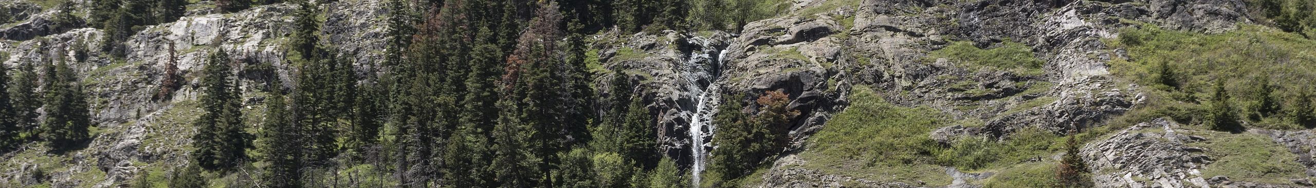
从地质和娱乐角度来看,这是一个极其多样化的区域。这里是一些美国最伟大的 高山滑雪 度假胜地,圣胡安山脉也构成了科罗拉多州最严峻的登山挑战 (圣胡安山脉中的达拉斯峰,通常被认为是科罗拉多州最高峰中最难攀登的一座,只能由技术熟练的登山者尝试)。另一方面,四角落附近的低洼地带似乎几乎没有“山峦” (尽管几乎到处都能看到远处的山峰),那里的主要景点是峡谷和台地风光,以及众多的祖先普韦布洛人遗址。
科罗拉多州西南部主要由两个地质特征构成:海拔高达 10,000 到 14,000 英尺 (3048 和 4267 米) 的山脉,沿着大陆分水岭的 西部斜坡,以及由温帕格雷高原和科罗拉多高原组成的区域。山地地区的落基山脉包括圣胡安山脉、埃尔克山脉和西埃尔克山脉等山脉,以及温帕格雷、圣米格尔、拉普拉塔和拉萨尔等较小的山脉。该地区散布着从矿业城镇改建的旅游度假胜地,如克雷斯特德比特、特柳赖德、杜兰戈和西尔弗顿。山脉仍在生长,由一块倾斜的构造板块向上推升,科学家推测这解释了为什么科罗拉多州西南部奇怪地没有像华盛顿州和俄勒冈州的喀斯喀特山脉那样的火山 (尽管过去曾有过火山活动,而且科罗拉多州西南部的一些地方,如 乌雷,遍布地热温泉)。
高原地区被科罗拉多河的支流,如甘尼森河和温帕格雷河切割,形成了深邃狭窄、峭壁陡峭的峡谷,包括甘尼森黑峡谷。该地区广阔的山谷和台地是像 三角洲、蒙特罗斯 和 甘尼森 这样的农业城镇的所在地。被誉为 科罗拉多葡萄酒产区 的该地区葡萄种植区,构成了北美最高的葡萄园。
科罗拉多高原 主要是一个干旱、岩石地区,有矮松林、箱形峡谷、高耸的悬崖、铀矿和石油勘探。这里有像 范迪姆 和 尤拉万 这样的 20 世纪艰苦的矿业城镇,以及一个富含考古发现的区域,如梅萨维德国家公园的悬崖宫殿。四角落地区的大部分被尤特山印第安保留地占据,这与更知名的纳瓦霍保留地不同,后者占据了亚利桑那州、新墨西哥州和犹他州跨越四角落地区的广大区域。
历史
[]
大约 10,000 年前,第一批人类进入科罗拉多州西南部。作为弗尔森文化的一部分,这些人被认为是亚洲跨大陆移民到北美的最早一批人之一。粗糙的工具和其他武器在温帕格雷高原被发现。
早在公元前 1500 年至公元 1300 年,祖先普韦布洛人(以前称为阿纳萨兹人)就居住在这里。他们用造型的石头建造房屋,建造半地穴式房屋,最终在岩石悬挑内部建造多层住宅。这些“悬崖宫殿”保存在四角落地区十几个国家公园和纪念地中。作为一个先进的文明,普韦布洛文化在中世纪的全球“小冰河时期”由于环境压力而崩溃。漫长的干旱可能迫使普韦布洛人放弃他们的村庄,到别处去种植庄稼。
大约在公元 1500 年,游牧民族尤特部落迁入科罗拉多州西北部,西班牙人紧随其后(至少在纸面上)。从 1820 年代到 1820 年代,西班牙声称科罗拉多州西南部的大部分地区是新西班牙总督辖区的一部分。边界在地图上并未固定,西班牙人只在科罗拉多州 中南部 进行了定居。
在 19 世纪,该地区与一个年轻的国家——美利坚合众国——发生了很大争执。在 1803 年路易斯安那购地之后,美国声称拥有阿肯色河以南和以西的所有土地。西班牙宣布其新墨西哥省圣达菲殖民地周围有大片贸易区,这一主张受到了美国的挑战。
根据 1819 年的《亚当斯-奥尼斯条约》,美国在购买佛罗里达州时放弃了对该地区的主张。1821 年,新西班牙总督辖区成功起义,脱离了西班牙王室。科罗拉多州西南部成为上加利福尼亚(墨西哥的一个省)模糊的北部边界的一部分。
为了开发该地区,墨西哥官员向山区 men、皮毛捕猎者和商人开放了土地。在 1821 年至 1840 年间,探险家安托万·罗比杜克斯 (Antoine Robidoux) 曾深入该地区寻找河狸皮毛。随着这些探险家和投机者的涌入,许多后来领导美国军队远征和政府测量队的 men 出现:基特·卡森 (Kit Carson)、“拓荒者”约翰·查尔斯·弗里蒙特 (John Charles Fremont) 和约翰·甘尼森上尉 (Captain John Gunnison)。
1846 年,美军入侵并击败了墨西哥,赢得了美墨战争。根据《瓜达卢佩-伊达尔戈条约》,美国获得了科罗拉多州西南部以及 加利福尼亚州、内华达州、犹他州,以及 亚利桑那州、新墨西哥州 和 怀俄明州 的部分地区。
在 1870 年代,圣胡安山脉南部发现了金银。美国军队强行将尤特人迁移到犹他州,以及科罗拉多州西南部的一个小角落,靠近 科尔特斯。
随着温帕格雷保留地于 1881 年向定居者开放,三角洲、蒙特罗斯和甘尼森等城镇迅速建立,为克雷斯特德比特、西尔弗顿和特柳赖德等矿业城镇提供服务。丹佛和格兰德河铁路铺设了经过圣胡安山脉的窄轨轨道,建立了如今仍在连续运营的最古老的铁路线路之一。
在接下来的 80 年里,畜牧业、农业和矿业一直是该地区工业的支柱。随着汽车的普及和可靠的公路系统的建立,科罗拉多州西南部越来越依赖旅游业作为收入来源。特柳赖德和克雷斯特德比特的矿业城镇在 20 世纪 60 年代和 70 年代被改造成滑雪度假胜地。这为该地区几个孤立的角落带来了新的资金和财富。
进入 21 世纪,科罗拉多州西南部继续以其崎岖的自然美景、丰富的娱乐机会和考古遗产吸引着人们。
对话
[]英语在这里通用,即使是在尤特保留地。有大量的西班牙语劳动者,他们是山区度假村、能源、建筑和酒店业的骨干。请参阅 西班牙语短语手册 了解更多关于如何更好地与这群人互动的信息。
此外,在滑雪小镇,有大量的、成熟的与来自 欧洲 和南美的大学生进行的交流项目。您会发现他们在这里经营滑雪缆车和设备租赁店,因此在滑雪季节听到 法语、德语 和 意大利语 并不罕见。但所有人都必须会说英语。
抵达
[]
要游览科罗拉多州西南部,游客需要乘坐飞机和/或驾车。
乘飞机
[]该州唯一的が主要机场是 丹佛国际机场,这是一个主要的航空枢纽,所有主要的国内航空公司以及一些国际航空公司都提供服务。一个更近的选择是位于该地区北部的 格兰德交汇 的沃克菲尔德机场,这是一个次要机场,由多家航空公司提供直飞 达拉斯/沃斯堡、丹佛、休斯顿、拉斯维加斯、洛杉矶、凤凰城 和 盐湖城 的航班,其中一些航班是季节性的。对于私人飞行员来说,也可以乘坐小型飞机前往机场,并在那里停留,然后游览该地区。机场也提供出租车和租车服务。
该地区内有三个小型机场,提供有限的商业服务。所有三个机场都提供租车服务。
- 科特兹市机场 (CEZ IATA) in 科特兹 has daily flights to Denver International Airport offered through Great Lakes Airlines。
- Gunnison-Crested Butte 地区机场 (GUC IATA) in Gunnison provides service to Denver, Dallas/Fort Worth, Houston, 芝加哥, and Los Angeles through Alaska Airlines, American Airlines, and United。
- 蒙特罗斯地区机场 (MTJ IATA) in 蒙特罗斯 is a small airport which has seasonal service on Allegiant Air, American Airlines, Delta, and United. Used most heavily during ski season。
乘汽车
[]- 科特兹 - US 160 runs east west from Durango and terminates in the center of town, joining the north-south running US 491. On 491, Cortez is situated between 蒙蒂塞洛, Utah to the northwest and 希普洛克, New Mexico to the south. It's 46 mi (74 km), or about an hour's drive from Durango, while it's 60 mi (97 km) or hour's drive from Monticello. From Shiprock, it's a 42 mi (68 km), or 45 minute drive。
- 德尔塔, 蒙特罗斯 - US 50 runs north-south from 大章克申 to the north, then curves and runs and east-west to Gunnison and 普韦布洛. US 92 runs east-west from 霍奇基斯, 帕奥尼亚 and 阿斯彭. Grand Junction is about 45 mi (73 km), or an hour's drive, while Aspen is 161 mi (259 km), or about 3 hours away。
- 杜兰戈 - To the south, 法明顿, New Mexico is about 30 英里(48 公里) away, about a one-hour drive. To the southwest, Cortez is about 45 mi (73 km) away and is also about an hour's drive. To the north, Montrose is 206 mi (332 km), or a two-hour drive on US 550. To the east, 沃尔森堡 is 221 mi (356 km) or 4 hours away on US 160。
- Gunnison - US 50 runs east-west from Montrose and Pueblo. From the west, it's about 65 mi (105 km), or an hour's drive from Montrose on US 50. From the east, it's 160 mi (258 km) or about 3 hours from Pueblo。
- Ouray, Silverton, - US 550 runs north-south from Montrose in the north to Durango in the south. It's about 60 mi (97 km) or an hour's drove from Montrose, and 48 mi (77 km) or an hour's drive from Durango。
乘火车
[]Amtrak has no direct service to this region; the closest train station is in 大章克申 on the daily 加州微风号 line between the 旧金山湾区 and 芝加哥。
乘巴士
[]Greyhound offers service to Delta, Durango, Gunnison, Montrose and Silverton; note that the stop in Silverton has no Greyhound ticketing office。
四处逛逛
[]
There's really no alternative to driving. Motorists should be aware that the eastern side of this region contains some seriously high passes, particularly Wolf Creek Pass on US 160 as it crosses the Continental Divide, and Coal Bank Pass, Molas Pass, and Red Mountain Pass on US 550 (the "Million Dollar Highway") between Durango and Silverton. These are commonly closed for periods of time during the winter. There are even "avalanche tunnels" along some of the routes, to prevent your car from being swept off the road into deep ravines by falling blocks of snow. The western part of the region is lower and less prone to road closures, but towns with gas stations and services are few and far between。
During the winter, heavy ice and snow are a major concern, which can make driving difficult and slow going. Always check the weather and road conditions before heading out. Even on a clear winter's day, make sure your vehicle's wiper fluid reservoir is full. The Colorado Department of Transportation (CDOT) spreads both sand and magnesium chloride on the roads, which makes for an impenetrable, gluey mess on your windshield。
In the summer months, it's not uncommon to see the shoulders of the highways littered with broken-down vehicles that could not handle the steep grades and high altitude air of the Rocky Mountains. If you are venturing from a lower altitude, make sure your car can handle mountain driving. Thinner air means you will be burning more gasoline. Also, with so many steep grades, expect to gear down to avoid unnecessary friction to your brake pads。
餐饮
[]World class dining is available in Telluride and 科罗拉多葡萄酒产区. There are a variety of restaurants available in Cortez and Gunnison, outside of the National Parks. Durango is another spot for decent dining。
But if you really want to eat authentically in the region, it's not that difficult to eat like an Ancestral Puebloan. A trip to one of Southwestern Colorado's many farmers markets can provide a lot of the same ingredients the Ancestral Puebloans cultivated: garden corn, squash, pumpkins and beans. They also raised turkeys and hunted game. A visit to a small town butcher that processes wild game could add venison, elk, sage hens, ducks and geese to your menu. The Ancestral Puebloans gathered sunflower seeds and pinon nuts from the mesa tops; you can gather these ingredients a little easier at the local grocery store. Coarse-ground cornmeal could be added to the list, as native women used to spend long, grueling hours grinding grain on stone metates to have enough to eat. A majority of these ingredients are available in restaurants, since they are still heavily used today in Southwestern cuisine。
Harder to come by are staples of the Ancestral Puebloan diet like prickly pears and yucca fruit. Pickled clean of their spines, the buds of the prickly pear can be cooked and served, as can its fruit. Also called Spanish bayonette, the yucca could be eaten raw, cooked, or mixed with other ingredients. The yucca's white blossoms taste sweet and can be eaten raw. Today, prickly pear is available fresh, canned and as jelly and candy, while a Central American cousin of the Southwestern yucca can be bought diced and frozen. Both foods are usually available at gourmet and natural foods grocery stores。
However, the biggest difference between you and the Ancestral Puebloan is how easily you procure your meal and how much you get to eat. The master builders of Chaco Canyon and Mesa Verde spent the majority of each day simply eking out a subsistence diet。
饮品
[]There are trendy bars, brewpubs, as well as honky tonks and a handful of authentic mining-era 19th century saloons. The mountain resorts are famous for their après-ski nightlife and clubs。
There is a long, storied history between drinking and the area。
It's unclear whether the Ancestral Puebloans drank. The conventional scientific wisdom says no, and that alcohol was introduced to Southwestern Colorado by the Spanish, 200 years after the Puebloan peoples left the region. However, a study conducted at Sandia National Laboratories says the Puebloans may have brewed their own beer using corn in clay pots. Using gas chromatography and mass spectrometers to analyze vapors produced by mild heating of pot samples, scientists produced chemicals associated with alcohol. So were the first microbreweries in the area inside the cliff dwellings of Mesa Verde? Perhaps not, since the corn could have fermented unintentionally on its own inside the clay containers。
Alcohol trickled into the region in between 1800 and 1840 with the arrival of the mountain men and fur trappers. Often working alone with long hours and in extreme conditions, many Mountain Men passed their leisure hours in the solace of drink. This is recorded in their first hand journals and in the legacy of the colorful vocabulary they left behind. For instance, cheap whiskey could be called arwerdenty whiskey, from the Spanish words "agua ardiente", which means "fiery water". Other terms for cheap whiskey include "John Barleycorn", "baldface", "panner piss", or "panther piss"). The trappers would carry this rot gut whiskey in a "jack of likker" a leather sack of fire water, or in "hollow woods", a Native American term for the small kegs used to haul alcohol. To drink was called "take a horn", since sometimes bone horns of bulls or bighorn sheep were fashioned into drinking flasks, or powder horns that usually contained gunpowder were converted for the purposes of partying. Whilst imbibing, the mountain men would chew or smoke "baccer" or "baccy" tobacco, also called "honeydew" or "ol Virginny", because a lot of tobacco was grown in the state of Virginia。
The culmination of all this hard living was in the drink, trade whiskey - a dubious combination of "red eye" whiskey, hot chili peppers, plug tobacco and gunpowder. (A gourmet recreation of the drink can still be sampled at The Fort Restaurant, in 莫里森, Colorado), near Denver. At summertime rendezvous with other trappers and in wintertime quarters like Fort Robideaux, the mountain men would drink themselves blind with earthen jugs of trade whiskey, inducing the euphoric good feelings the fur trappers dubbed, "Shinin Times"。
One note of caution - while experiencing your own "Shinin Times," you may want to take it a little slower at first. Some people find that their alcohol tolerance is lower at higher altitudes. Drink slowly until you acclimate. Otherwise, the consequences may include extreme hangover and nausea。
注意安全
[]
健康
[]There's no reason to fear the mountains, as long as you approach them with proper respect and preparation. As with anywhere else, recklessness and a lack of forethought can get you into trouble, especially in Colorado's vast back country。
- 高原反应 - Can lead to dizziness, headaches, nausea, even blackouts and pulmonary edema. Give your body a few days to adjust to the high altitudes before going full throttle with your hiking or skiing。
- Dehydration - When you engage in strenuous outdoor activities, be sure to replenish your fluids as you go. You may be losing moisture through your mouth and nose and through sweating, but be completely unawares due to the arid mountain air. May result in dizziness, intense thirst and elevated heart and breath rates。
- Giardia - Drinking untreated water from regional streams is not a good idea owing to Giardia parasites, but tap water is not a problem。
- Hypothermia - Prolonged exposure to the cold can result in confusion, a slowed heart rate, lethargy, even death. Dress warmly in non cotton clothing to allow any sweat to wick away from your body and evaporate. Otherwise, it may thoroughly chill you later in the day when temperatures drop。
- Frostbite - During periods of severe cold, your circulatory system pulls all your warming blood into the core of your body to protect your vital organs. This makes your extremities such as your ears, fingers and nose especially vulnerable. Wear a face mask, insulated gloves and other heavy gear on the worst winter days. It gets cold sitting still on those ski lifts!
- Sunburn - Lather up with sunscreen, even if there's cloud cover. Colorado's high elevation means you have less protection to the sun's powerful ultra violet rays. This can be compounded while skiing or snowboarding, when the rays are reflected off the snow and hits the underside of your jaw. Don't forget to wear UV-rated goggles or sunglasses, as well. There's nothing more painful than sunburned eyeballs。
安全
[]- Avalanches - Colorado claims about a third of all avalanche deaths in the U.S. The ski resorts have groomed slopes that are safe, but it is extremely dangerous to ski or snowboard outside of the designated terrain. It's popular amongst daredevil skiers to "run the shutes," steep, shaded slopes that funnel into tight gullies. These are classic avalanche zones. Far more common (and deadly) are slab avalanches that break along a fault line and bury unsuspecting snow mobilers or skiers. Always wear a homing beacon and check the conditions at the Colorado Avalanche Information Center before heading into the back country。
- Lightning - This is especially deadly in the high country above timberline when no shelter is nearby. If you hear crackling or hissing sounds, or your hair begins to stand on end, squat down immediately in the "lightning desperation position" - feet together and your hands clapped over your ears. Remember, a tent and inflatable mattress offer no protection from a lightning strike. Avoid the high ground, or solitary objects like trees that stick out higher than the surrounding terrain (they may act like natural lightning rods). For more information, see the safety tips at the National Oceanic and Atmospheric Agency (NOAA)。
下一站
[]- 西北科罗拉多州 lies to the north, and is a diverse area of both red rock country and snow-capped peaks. Within this area is 科罗拉多国家纪念碑, red rock pinnacles, arches and other geologic features, the rich fossil beds of 恐龙国家纪念碑, the trendy ski town known of 阿斯彭, and 维尔, with some of the largest ski slopes in North America。
- To the east, on the other side on the San Juan Mountains, is the San Luis Valley of 南科罗拉多州中部. Within the valley is 大沙丘国家公园, which holds North America's tallest dunes。
- The canyon and mesa country of the larger Four Corners region, including 新墨西哥州西北部 to the south and Utah's 峡谷国家 to the west, offers many more famous national parks and monuments that preserve red rock wonders and Ancestral Puebloan ruins。