奈恩瀑布省立公园50.56329-122.66451比尔肯海德湖省立公园,Blackwater Creek Rd(从库里山出发,沿99号公路向东行驶。在主交叉口,直行(D'Arcy Road)。Blackwater Rd岔路口位于左侧,距离公路约33公里).维护良好的土路。公园以一个环绕着群山的非常美丽的湖泊为特色。有一个海滩可供游泳,并提供皮划艇租赁。还有几条适合一日游的中等难度徒步路线,通往湖泊南端,平行于南北岸。公园南端的尖端位于100年租约内,有一个带有私人入口的细分区。日间使用免费。皮划艇租赁为20/30/50美元(一小时/半天/全天).
50.5757-123.45942Meager Creek Hot Springs,Upper South Creek FSR 11 km + 4 km up hill + 9.5-km trail(2 hours and 64 km west of Pemberton: take the paved Pemberton Meadows Road, do not turn off, it becomes a gravel municipal road, that then becomes the South Creek FSR. At 40 Km the road forks. Take the up-hill south fork (left) on very rough zig-zagging dirt track of an old logging road for about 4 km, then 6 km along VOC Harrison Hut Trail where it meets the old Meager Creek Hot Springs Trail for 3.5 km more. Or, via Miller Creek over the pass, or down off the Meager Glacier or Pemberton Ice Cap.).24/7.Three beautiful volunteer-built cascading large pools, with the lowest pool beside Meager Creek. No dogs or camping allowed poolside. Best to keep dogs leashed as it is a wildlife area, i.e. mountain sheep, mountain goats, coyotes, wolves, deer, moose, grizzlies & black bear. Vehicle access: 4-wheel drive vehicle or a full size pick-up with high clearance. Or deep winter via snow mobile.Free & Free Bush Camping for now, but expect fees if trail tenure is granted.
49.937778-122.4083333Skookumchuck Hot Springs(T'sek Hotsprings, Saint Agnes Well Hotsprings),In-shuck-ch Forest Service Road(1½ hrs to the East of Pemberton just before the town of Skookumchuck (trad.) renamed Skatin is on the In-shuck-ch Forest Service Road, In Shuck ch FSR, AKA Lillooet River Road, North.).Key words Google Maps: Skookumchuck Hot Springs.$10/vehicle, $10/person, kids 10 and under free. If you don't overnight there's no vehicle charge. $7.50 per adult overnight for camping.(updated Feb 2018)
49.741-122.3014Sloquet Hotsprings(Sloquet Hot Springs),Sloquet Creek FSR 10 Km(Can be accessed from the north by way of Pemberton & Mount Currie or from the South on FSR/logging roads on the west side of Harrison Lake.).24 / 7.The Hotsprings consists of a series of small but excellent hot pools in a wilderness setting. Hot water pours out of the forested side of the bank of Sloquet Creek & flows into 2 intimate 2-person double upper pools- tight fit, then into the larger shallow lower pool. On occasion, the water in the upper pools may be too hot to bathe in. The 3rd pool farther down the creek is just right temperature.$5 day use & $15 camping at trail head.(updated Aug 2015)
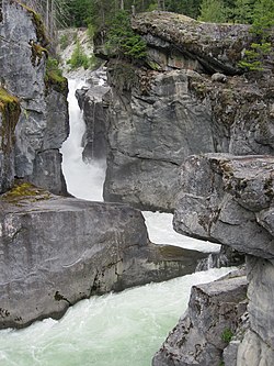
Nairn Falls
Climbing: surrounded by the Coastal Mountains, Pemberton has some of BC's finest hiking and back country camping opportunities. It also offers many opportunities for rock climbing and mountaineering. While not as popular as Squamish, there are several climbing areas located within a short drive of the village. Detailed listings can be found in any of the area's climbing guide books.
其他:
50.30313-122.753295Sunstone Golf Club,1730 Airport Rd(10 mins east of Pemberton just before Pemberton Airport.),☏ +1 604-894-6197,toll-free: +1-800-390-4653.A par 72 course with full service club house.$25-69, depending on day of week and time of day.(updated Mar 2023)
50.30379-122.767576Big Sky Golf,1690 Airport Rd(10 mins east of Pemberton just before Pemberton Airport. Clubhouse down Big Sky Drive),☏ +1 604-894-6106,toll-free: +1-800-668-7900,fax: +1 604 894-5545,info@bigskygolf.com.Summer: Su–Th 8AM–8PM, F Sa 8AM–9PM; other seasons shorter hours.18-hole course with a 19th hole bar & restaurant.Moderate prices.(updated Oct 2017)
50.334896-122.8124637Cayoosh Expeditions(Often meet at Old Community Centre Playing Fields Park),guiding@cayooshexpeditions.ca.Experienced paraglider pilots and skilled outdoor guides Corinne and Jim offer tandem paraglider pilots in some of the best free flight conditions in North America. They have been building the sport of paragliding in the Pemberton Valley for decades. They also can sell paragliding gear, up to complete wing and harness sets.Tandem flight $240.(updated Oct 2017)
50.334704-122.8124638Sea To Sky Paragliding(Frequently meet at Old Community Centre Playing Fields Park),☏ +1 778-892-7733,fly@s2spg.com.May–October, by appointment.Instructor pilot Guy offers tandem paraglider flights, mostly from Mt Mackenzie. When the Canadian National Paragliding Championships were held here in 2017, Guy organised them.Tandem flight $240.(updated Oct 2017)
Biking: Almost 200 km of free trails for cross-country skiing, biking, walking, or riding a horse in the whole Valley System.
Ironman triathlon.23 km from Whistler Town limits to Pemberton. It's a popular, though challenging, hilly route. Part of the annual Whistler - Pemberton IronMan Canada Race.(updated Jul 2016)
50.32186-122.806371Be Natural, herbal apothecary and foods,108, 7433 Frontier St(In the AG Foods strip mall),☏ +1 604-894-8884.A health food store offering vitamin supplements, herbal blends, homeopathics, essential oils, personal care, bulk herbs and foods, healthy snacks, and specialty and organic groceries. Private health consults available by a trained Clinical Herbalist with knowledge in herbs, vitamins, nutrition, Bach Flowers, Reiki, and Reconnective Healing.
50.315708-122.7259412Pemberton Distillery,1954 Venture Pl(15 min east of Pemberton proper in the Pemberton Industrial Park adjacent to Mount Currie),☏ +1 604-894-0222,fax: +1 888-894-3676,info@pembertondistillery.ca.Retail shop and tastings: F-Sa noon-6PM; Tours: Sa 4PM.Local maker of spirits and some non-alcoholic mixers. They're most noted for their Schramm Organic Potato Vodka, made out of local "Pemby" spuds, gin, absinthe, whiskey and fruit liqueurs, which is available on-site and served at some local establishments in Whistler and Pemberton. Tastings and tours available; call ahead. During summer, also at Pemberton Farmers Market, the Barn in downtown, W 3:30–6:30PM.(updated Oct 2017)
50.30869-122.74111North Arm Farm,1888 Hwy 99(5 km east of the McDonalds & PetroCan gas station),☏ +1 604-894-5379.9AM-6PM daily.Local farm with a produce shop and bakery. They sell their own organic produce and produce and cheese from other BC farms. There is also a lunch menu with home-made sandwiches.Coffee $2.15, sandwiches $6-10, baked goods $2-5.(updated Mar 2023)
50.317986-122.7987982Mile One Eating House(Mile One),107-7330 Arbutus Street(under the red clock tower & across from the Petro-Canada gas station at the junction of Portage Rd and Hwy 99. Frontage on Portage Rd at the Pemberton Gateway Village Suites Hotel Building),☏ +1 604-384-3842.Tu-Su 11AM-9PM-ish.Not fast food, but fast slow food. Independently owned and operated, offering breakfast, lunch and dinner. The cuisine is "100 mile" inspired, with local natural beef and potatoes from the Valley, buns from the bakery across the street, Ocean Wise tuna caught off the Coast, and BC cheeses and veggies. WiFi hotspot.Moderate prices.(updated Mar 2023)
50.321383-122.8062083BlackBird Bakery,7424 Frontier St(Hidden in the old train station),☏ +1 604-894-6226,info@blackbirdbread.com.M-Sa 6AM-6PM, Su 7AM-5PM.Croissants, cinnamon buns, freshly baked breads. Fresh roasted and ground coffees. There's a small comfy couch in back and a small south facing terrace. WiFi hotspot.Moderate prices.(updated Oct 2017)
50.31807-122.79894Mount Currie Coffee Company(Mount Currie Coffee),2-7331 Arbutus St(beside Pemberton Gateway Village Suites Hotel, 1st right off Hwy 99 entering Village),☏ +1 604-894-3388,info@mountcurriecoffee.com.6:30AM–6PM.Local favourite for coffee, gelato and paninis. Sit outside in the covered all weather patio. WiFi hotspot.Moderate prices.(updated Mar 2023)
50.31768-122.799655BackCountry Pizza,104-1436 Portage Road(Hidden under the water tower at Portage Place. Turn off Hwy 99 at the 1st & only traffic light. Diagonal corner from Pemberton Gateway Village Suites Hotel. Across the street from Arbutus),☏ +1 604-384-1888.Daily approx 10AM-10PM.Small south facing terrace. Great pizza by the slice. Eat at the small counter or take out. A local favourite.moderate.(updated Aug 2015)
50.317782-122.799716Portage Station Restaurant,1436 Pemberton Portage Road(also hidden under the water tower at Portage Place; turn off BC Hwy 99 at the 1st & only traffic light. Diagonal corner from Pemberton Gateway Village Suites Hotel, across the street from Arbutus),☏ +1 604-894-1100,paul@pembertonrestaurant.com.Daily 8AM-9PM.2 patios & a long sit up bar. Great Local craft beer selection. Breakfast menu includes Eggs Benedict.(updated Aug 2017)
50.322813-122.8074167Pemberton Valley Supermarket,7438 Prospect St,☏ +1 (604) 894-3663.Daily 8AM–9PM.If you are cooking on your own, this is a quite serviceable place to get a full line of groceries and fresh produce. There is a nice deli at the front offering hot meals and sandwiches.(updated Oct 2017)
50.300474-122.7498178Sunstone Bar & Grill,1730 Airport Road(in the clubhouse of the Meadows at Pemberton),☏ +1 604-894-6197 ext 5,toll-free: +1-800-390-4653,info@pembertongolf.com.Summers; reduced hours spring, fall; closed winter.Meals in a beautiful green setting surrounded by high mountains. In summer, the open, high-roofed deck is insanely pleasant. Watch incoming aircraft fly by low on their approach to nearby Runway 06. Satisfactory vegetarian options.Entrées $14-24.(updated Oct 2017)