
纪念碑谷
纪念碑谷(纳瓦霍语:Tsé Bii' Ndzisgaii)也许是美国西部经典景观中最著名的例子。它位于纳瓦霍族保留地,靠近亚利桑那州和犹他州的边境,山谷曾是许多电影和广告的背景,从万宝路香烟广告到约翰·福特导演的电影,再到《回到未来3》、《阿甘正传》和《逍遥骑士》。在电影和电视中,其景观常被用来代表牛仔时代的西部,或象征大陆分水岭的穿越。山谷主要位于亚利桑那州北部,但公园北部则在犹他州。最近的城镇是凯恩塔,距离南方约20 英里(32 公里)。
了解
[]
纳瓦霍族保留地和犹他州将于四月至十月实行山区夏令时,但亚利桑那州不实行夏令时,因此当您身处亚利桑那州且不在纳瓦霍族保留地内时,时间将提前一小时。
美国的地域辽阔,许多人没有预留足够的旅行时间,尤其当他们习惯了欧洲或亚洲较短的行程距离时。许多纪念碑谷的游客来自欧洲和日本,他们很难理解在目的地之间需要花费的旅途时间。如果您从拉斯维加斯或凤凰城出发,您的行程将花费几乎一整天。您无法在同一天内游览纪念碑谷并继续前往南部的大峡谷以及北部的摩押。即使在纪念碑谷停留一夜,与该地区纳瓦霍族保留地的景点数量相比,您的停留时间也显得非常短。
山谷被纳瓦霍族视为极其神圣之地。请尊重他们的土地,务必沿现有道路行走,不要尝试攀爬岩石构造。
历史
[]考古证据表明,古代普韦布洛人(以前称为“阿纳萨齐”,但该术语被当今普韦布洛人视为冒犯性称谓)在公元1300年之前就居住在该山谷。如今,已在西南部发现了超过100处可追溯到这些古代人的遗址和废墟,包括岩画。普韦布洛人在14世纪离开了该地区,当时当地环境发生了持久性的变化,使得该地区难以进行大规模居住,直到纳瓦霍人到来之前,这里一直没有人定居。
19世纪60年代,美国矿工梅瑞克(Merrick)和米切尔(Mitchell)在该地区发现了银矿。他们将银带回附近的矿业城镇,并召集投资者开始采矿作业。第二次采矿作业成功启动。然而,他们失踪了——银矿也随之消失。
20世纪中期,纪念碑谷因在此拍摄了大量西部片和牛仔片而声名鹊起。因此,纪念碑谷已成为狂野西部的象征,拥有其荒漠般的严酷气候和壮观的岩柱。
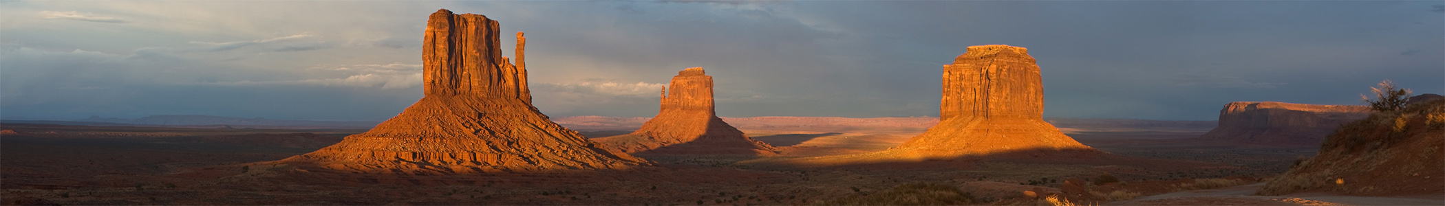
地貌
[]纪念碑谷的景观使其辨识度极高。该地区以干旱、覆盖着鼠尾草的山谷为主,但有巨大的岩石露头使得山谷独具特色。山谷两侧是岩石峭壁,峭壁内部隐藏着峡谷。岩柱本身的高度通常只有几百英尺(与大峡谷的大小相比很小),但峭壁的极陡角度和垂直度使其与大环线国家公园一样壮观。
但近距离观察,环绕岩柱的平坦草原实际上相当多样。近距离观察,沟壑(小峡谷)、沙丘以及岩石露头使得穿越山谷的过程更加有趣。然而,负面影响是,即使远离岩柱,在纪念碑谷徒步也非常困难。沙丘高得惊人,而且很难攀爬,因为红色的土壤同样难以征服,与其他类型的土壤一样。
纪念碑谷的红色土壤与该地区和海拔有关。通常,科罗拉多高原海拔5000至6000英尺(约1500至1800米)的地区会呈现红色沙质土壤,而纪念碑谷以西的地区(海拔超过6,000 英尺(1,800 米)海拔)则呈现黄色的土壤颜色。换句话说,如果纪念碑谷的海拔再高一千英尺,它就不会成为一个如此有趣的公园了。
动植物
[]
纪念碑谷地区拥有各种各样的植被,包括杜松、丝兰、俄罗斯蓟(风滚草)和纳瓦霍茶。许多植被至今仍被纳瓦霍人用于药用,并用作他们世界闻名的手工编织地毯的染料。
科罗拉多高原地区的四角地区的景观常常覆盖着隐生土壤,这是一种由活的蓝细菌、绿藻、褐藻、真菌、地衣和/或苔藓组成的生物土壤结皮。隐生土壤结皮是沙漠生态系统的重要组成部分,它通过稳定沙土、促进水分保持和固定植物所需的氮来促进其他植物的生长。由于其纤薄的纤维状结构,隐生土壤系统极其脆弱。单一的脚印或轮胎印就足以破坏土壤结皮并损害其中的生物。尽管土壤结皮系统中的某些物种在扰动后几年内可能重新生长,但生长缓慢的物种可能需要一个多世纪才能恢复到原来的生产力。
这种对扰动的敏感性意味着旅行者应该注意他们对隐生土壤的影响。一般而言,游客应沿现有道路和步道行走,仅在坚固的表面(如基岩或河砂)上脱离步道。
气候
[]
夏季气温在80多华氏度到90多华氏度(约27-33摄氏度)之间。冬季白天气温通常高于冰点,夜晚低于冰点,有时夜间会降至零华氏度(约-18摄氏度)以下。预计最后一次霜冻在5月15日左右,第一次霜冻在10月某个时候。夏季夜晚凉爽舒适,气温在60 华氏度(16 摄氏度)至80 华氏度(27 摄氏度)。夏季干燥,除非在季风季节——此时要警惕山洪暴发。冬季会有降雪,有时会在地面停留数周,为岩石构造带来新的、壮观的景象。
与科罗拉多高原大部分地区一样,纪念碑谷的气温不像死亡谷那样炎热,因为海拔较高。尽管气温有时会很高,但冬季也会异常寒冷。游览公园的最佳时间是三月、四月、五月或十月。但如果您想看雪,可以在十二月或一月去公园。
从加利福尼亚太平洋海岸到落基山脉,由于“雨影效应”,会发现一个普遍的气候趋势——海拔越高,年降水量越高;海拔越低,则越干燥。
| 纪念碑谷 | ||||||||||||||||||||||||||||||||||||||||||||||||||||||||||||
|---|---|---|---|---|---|---|---|---|---|---|---|---|---|---|---|---|---|---|---|---|---|---|---|---|---|---|---|---|---|---|---|---|---|---|---|---|---|---|---|---|---|---|---|---|---|---|---|---|---|---|---|---|---|---|---|---|---|---|---|---|
| 气候图(解释) | ||||||||||||||||||||||||||||||||||||||||||||||||||||||||||||
| ||||||||||||||||||||||||||||||||||||||||||||||||||||||||||||
| ||||||||||||||||||||||||||||||||||||||||||||||||||||||||||||
抵达
[]靠近纪念碑谷的城镇包括佩吉、卡纳布、布拉夫、图巴城和凯恩塔。然而,这些城镇通常离纪念碑谷太远,无法作为酒店所在地(凯恩塔除外)。
乘汽车
[]一些旅行者可能会认为纳瓦霍族保留地内的公路和主要道路(包括通往公园的道路)与美国其他地区的道路不同;然而,事实并非如此。纳瓦霍族保留地内的美国国道和其他主要道路与美国其他地区的主要道路相同。然而,一旦您驶入该地区散布的小村庄附近的小路,情况就不同了——许多小地方道路在一定程度后就没有铺装了。
驾车进入纪念碑谷的旅程很简单,只要游客走主要道路进入公园和周边地区即可。只有当人们试图走“捷径”时,事情才会出错。您可能会开始沿着一条看似良好且铺装的侧路行驶,但沥青路面在接近城镇的地方会突然结束,道路质量会迅速下降。即使地图上显示进入公园或纳瓦霍族保留地的路线看起来更短,它可能也不是一条更快的路线。
对于驾车进入纪念碑谷的游客来说,高速公路很安静,在大部分前往公园的路上,您可以以超过60 英里/小时(97 公里/小时)的速度行驶。然而,进入公园后您需要减速。
以下是一些进入纪念碑谷的重要道路,离公园最近的列在最前面,最远的列在最后
- 纪念碑谷路通往纪念碑谷部落公园本身和纪念碑谷游客中心。靠近古尔丁旅馆(纪念碑谷部落公园以西),这条路分为两条,一条叫奥尔杰托路(Oljeto Road),另一条叫岩门峡谷路(Rock Door Canyon Road)。岩门峡谷路经过古尔丁的一些旅馆和一间教堂,然后变成一条土路。
- 美国163号公路是进入纪念碑谷的主要美国国道。163号公路的南端在亚利桑那州凯恩塔(纳瓦霍族保留地),向北穿过纪念碑谷前往墨西哥帽子,并最终与美国191号公路相交。191号公路连接美国163号公路与峡谷地国家公园和拱门国家公园。
- 可以从弗拉格斯塔夫和大峡谷出发,经美国89号公路向北前往保留地城镇卡梅隆,然后走美国160号公路到凯恩塔,最后沿美国163号公路向北即可到达纪念碑谷。
- 离纪念碑谷最近的州际公路是西边的I-15,北边的I-70,以及南边的I-40。从这些州际公路出发,您需要走美国国道或州道才能到达纪念碑谷。
乘飞机
[]凯恩塔有一个机场,但这个机场不过是两架飞机和一条跑道。纳瓦霍族保留地内还有许多其他小型机场。
佩吉(Page)、图萨扬(大峡谷机场)和弗拉格斯塔夫有区域机场。从这些机场出发,您需要租车开往山谷。这些区域机场的租车服务可能有限。摩押有一个机场,接收来自丹佛和洛杉矶等城市的常规航班,但仍然需要大半天才能到达山谷。
较大的机场在凤凰城——距离320 英里(510 公里),车程约5小时——以及在拉斯维加斯——距离400 英里(640 公里),车程约6.5小时。拉斯维加斯机场对于前往大峡谷(尤其是北缘)然后可能继续前往纪念碑谷的游客来说很方便。
费用和许可证
[]通行证和费用
[]纪念碑谷大部分地区属于纪念碑谷部落公园,是一个纳瓦霍部落公园,因为纪念碑谷位于纳瓦霍族保留地内。部落公园与美国国家公园不同,纪念碑谷部落公园收取每车20美元的费用(含4人;每增加一人额外收费6美元),可进入山谷的环形路。
由于纪念碑谷部落公园是纳瓦霍部落公园而非国家公园,因此不接受国家公园通行证。
入口
[]除少数几条小径外,想要徒步穿越山谷或参观环形路以外景点的个人必须聘请纳瓦霍向导,并支付额外费用。这是为了确保公园自然环境和野生动物的安全,以及徒步者的安全,避免他们迷路。
四处逛逛
[]乘汽车
[]旅游路线
[]不仅有许多道路通往公园或进入公园,还有许多道路环绕纪念碑谷部落公园。然而,这些道路主要供居住在公园内外的纳瓦霍人使用,而非游客。只有旅游车辆允许在这些土路上行驶。公园内的这些土路并非优质土路;它们就像在崎岖地形上划出的线条;对坡度和道路障碍的考虑非常少。事实上,有些道路甚至穿过沙丘,造成颠簸的旅程。
尽管并非所有旅游/当地路线都清楚地标明仅供旅游和纳瓦霍人使用,但通常最好避免通过土路和其他次要路线在公园内穿行,因为这些道路会通往真正属于纳瓦霍族保留地的区域。
公共道路
[]美国163号公路和通往公园的铺装道路都是优质道路。通往游客中心的道路限速较低,但仍然是进入公园区域的良好路线,并且比该地区任何土路都要好得多。美国163号公路以大致南北方向穿过公园,尽管在公园北部它会转向东。公路上的唯一弯道发生在岩石露头挡道或附近有纳瓦霍人居住区时。这条主干道是双车道,但仍然适合通行。
主公园道路连接古尔丁旅馆(西部)和纪念碑谷游客中心(东部)。这条道路在古尔丁旅馆附近与163号公路相交,使其成为连接纪念碑谷公园与附近设施的重要纽带。它大部分是一条快速道路,但游客中心附近的限速较低,因为公园入口收费处在此。在古尔丁旅馆,道路分为两部分,其中大部分分叉道路对于纪念碑谷的行程并不重要。
与国家公园类似,纪念碑谷有一条指定的风景道路,带您游览山谷中最美的部分。纪念碑谷的指定道路是一条十七英里(27公里)长的未铺装环形路,从游客中心附近开始,向南延伸至纪念碑谷中拥有大多数岩柱、尖峰和平顶山的地带。环形路未铺装,可能非常颠簸且多尘。截至2018年夏季,不建议非高底盘车辆行驶此路。只有SUV、货车或其他高底盘车辆才可通行。道路部分区域有太深的坑洞,标准车辆难以轻松通过,尤其是在环形路的单行道段——如果您尝试驾驶普通汽车上路并开始后悔,请在与单行道汇合处掉头,以免后悔莫及。环形驾驶最少需要30-40分钟,但大多数游客会花上几个小时来欣赏风景。有提供高底盘车辆的环形路导览,但通常是开放式座位,您会沾染灰尘,夏季还会非常炎热。未经当地向导陪同,您不得偏离环形路线。不乏愿意(当然是收费的!)带您进入限制区域的当地向导。
一个重要的事实是,纳瓦霍人允许他们的“驯养”动物自由活动,包括牛和马,并且很少将它们围起来。因此,动物偶尔会跑到山谷的主要道路上,所以请小心驾驶(在小路上慢行),以避免撞到这些动物。动物被放养在公园区域,直到主人需要并找到它们。
加油站
[]纪念碑谷的主要加油站是古尔丁加油站,位于古尔丁旅馆附近,距离美国163号公路以西不远。加油站还设有洗车服务。
步行
[]考虑到公园的规模和美丽的风景,纪念碑谷的徒步机会相对较少。唯一主要的自助徒步道是野猫小径(Wildcat Trail),但由于该地区沙丘众多(在沙地上标记小径很难),这条小径极其难以辨认。然而,游客不允许自由探索公园,因为公园和纳瓦霍族不希望人们破坏那里的植物或意外闯入纳瓦霍人居住区。不过,已经安装了标志来指示小径的走向。如果您没有看到任何标志,您可能已经走错了路,离开了正确的小径。
有趣的是,即使在跟团游中,徒步也很少。这些旅行中唯一的步行是从车辆走到观景点或其他景点。
请记住,山谷的大部分地面覆盖着隐生土壤(类似于拱门国家公园附近的土壤),这是一层非常薄的土壤,含有微生物和苔藓,构成了当地生态系统的基础。由于它是一层非常薄的土壤,很容易被脚步或轮胎印损坏。这些土壤层需要上百年才能重新生长,所以为了拍一张好照片而脱离小径的行为可能会在一百年内毁掉一个当地的生态系统!请务必沿着小径行走,或跟随当地的纳瓦霍向导。他们会告诉您可以在哪里行走,以免打扰环境。
看
[]虽然公园内通往主要岩石构造的自助小径非常少,但您可以在美国163号公路上看到这些岩石构造(通常被称为“手套”)。山谷两侧有许多红色的岩石峭壁,也可以从主路上看到。

山谷区域
[]虽然纪念碑谷没有特定的名称区域,但可以将其划分为几个部分。
公园总部
[]这 纪念碑谷部落公园总部以及其东侧的乡村是最容易到达的纪念碑谷公园区域。酒店、餐厅和游客中心都位于同一个主建筑内,旁边是一些最好的纪念碑谷观景点,您可以在此进行自助徒步,近距离欣赏纪念碑谷的景色。一条未铺装的道路(对公众开放)也从公园总部向东南延伸,通往纪念碑谷东部。
公园总部北侧有一个露营地和一些小木屋。
纪念碑谷东部
[]纪念碑谷东部拥有最密集堆积的尖峰、岩柱和平顶山。这里发现了许多奇特的岩石构造,但到达它们并不太难,因为17英里(25公里)的环形路穿过这些岩石构造。如果您想快速领略纪念碑谷的最佳风光,请前往该地区。
纪念碑谷东部也有一些不错的观景点。这些观景点通常位于东部纪念碑谷的北部,因为东部纪念碑谷的海拔比约翰·福特观景点以北的区域要高——尽管它仍然低于游客中心和公园总部的高度。
.jpg)
尽管环形驾驶和许多岩石构造都在东部纪念碑谷,但这里没有徒步小径。东部纪念碑谷的南端比其北端更偏远。
纪念碑谷西部
[]尽管 纪念碑谷西部是最难到达的纪念碑谷区域之一,其地形最多样化且最有趣。它实际上是两个独立的区域:一个区域有高耸岩石构造环绕的狭窄峡谷,另一个区域则有较小的、圆形的岩石构造,称为“蟾蜍石”。纪念碑谷的这部分只能通过导游到达;然而,您可以从该地区获得与更受欢迎的纪念碑谷地区一样多的信息。
虽然西部纪念碑谷不是约翰·韦恩电影的拍摄地点,但它弥补了历史的不足,有一些废弃的古代普韦布洛人定居点。古代普韦布洛人居住在峭壁侧面和小型洞穴中,并在洞穴外侧建造墙壁。这让他们在内部有一个小房间,用于烹饪食物。
再往西,在163号公路以西,地形变得荒芜,岩石的颜色变成白色。一些导游可能会去163号公路以西,但他们大部分时间不会去。163号公路以西曾有铀矿,现已关闭,但该地区尚未完全净化。

纪念碑谷北部
[]纪念碑谷北部部分位于犹他州和亚利桑那州,位于公园总部北部和东北部。导游通常不进入山谷的这一部分,体验它的最佳方式是从公园总部、野猫小径或美国163号公路远眺。
北部纪念碑谷的岩柱和平顶山不如东部纪念碑谷常见,但这使得它们更加壮观。北部纪念碑谷的岩柱可能是整个山谷最容易辨认的特征。最靠近公园总部的北部纪念碑谷岩柱曾出现在电影《驿马车》中。野猫小径环绕着形状像手的北部纪念碑谷“手套”,这些“手套”位于北部纪念碑谷,但靠近东部纪念碑谷。
在纪念碑谷最北端,美国163号公路在鹰峰(Eagle Mesa)和布里格姆墓(Brigham's Tomb)之间穿过一个名为“纪念碑山口”(Monument Pass)的地方。除了几英里外的火车岩(Train Rock),这些是纪念碑谷最北端的岩石构造,纪念碑谷基本上在这里结束——想看更多的岩柱、尖峰和平顶山,您可以向北行驶几百英里到拱门国家公园。
古尔丁和纪念碑谷镇
[]尽管古尔丁旅馆和公寓不在纪念碑谷部落公园内,但它们在实际意义上是纪念碑谷的一部分。这个区域是纪念碑谷的西北部,距离纪念碑谷公园主体以及岩柱和尖峰有几英里。它是163号公路以西唯一重要的区域。主干道(从游客中心向西延伸的道路)在古尔丁旅馆附近分为两部分,南侧道路穿过两座平顶山到达一个名为“山谷之隙”(The Gap)的山口。从古尔丁露营地和公寓出发,有几条短小路径通往山谷之隙的北侧平顶山,这里至少有一个拱门。
如果您从古尔丁继续向西行驶,这条穿过山谷之隙的主路叫做“岩门峡谷路”(Rock Door Canyon Road),它穿过纪念碑谷镇,通往马场峡谷(Horse Pasture Canyon)。这里,峡谷变宽,道路从犹他州进入亚利桑那州,停止铺装,变为6410号公路。
景点
[]
拱门
[]虽然纪念碑谷也有拱门,但拱门在犹他州著名的拱门国家公园更为常见。
- 大霍根拱门 (纪念碑谷东部). “大霍根”的名字来源于拱门的外观,与霍根(Hogans)相似。霍根是纳瓦霍族保留地常见的圆形建筑。过去,“大霍根”是印第安人聚会的地方,由于拱门的共鸣效果,非常适合传统的纳瓦霍音乐。


- 风之耳 (纪念碑谷东部). 拱门旁边有一个沙丘。
- 古尔丁拱门 (小径标志指向该地点;古尔丁区域). 古尔丁旅馆附近的一个峡谷里有一个大拱门。有几条小径通往该区域。
- 隐桥拱门 (纪念碑谷东部). 这个拱门是一个岩石构造的一部分,位于大霍根和风之眼以南。
- the Moccasin Arch (纪念碑谷东部). 这个拱门在大霍根旁边。Moccasin Arch位于一个比Big Hogan小一些的洞穴中;然而,它的拱门更加明显。
- 风之眼 (东纪念碑谷). 这座拱门很独特,因为你可以从它下方的岩石构造中看到它。
台地、孤峰和尖塔
[]岩石露头通常包括陡峭的悬崖,顶部有相对平坦的区域。这些露头实际上分为三类:台地(mesas)、孤峰(buttes)和尖塔(spires)。台地有最大的平顶,孤峰有较小的顶,而尖塔则完全没有平顶。
- 布里格姆墓孤峰 (北纪念碑谷). 孤峰,位于纪念碑山口和美国163号公路以北,在纪念碑谷最北端。它以著名的摩门教领袖布里格姆·杨(Brigham Young)的名字命名。
- 骆驼孤峰 (东纪念碑谷). 这是靠近约翰·福特角(John Ford's Point)的一个小孤峰。泥土路绕过孤峰的三个侧面;一条路在其西侧,在孤峰和另一个孤峰之间;一条路在其南侧,在骆驼孤峰和南边另一个孤峰之间;另一条东边路则穿过拇指尖塔(Thumb Spire)北部通往北窗观景点(North Window Overlook)。
- 鹰台地 (北纪念碑谷). 这是纪念碑谷最北端的台地。它毗邻坐 hen(Sitting Hen)且靠近布里格姆墓(Brigham's Tomb),因此在纪念碑山口(Monument Pass)的视野范围内。
- 大象孤峰 (东纪念碑谷). 这座壮观的孤峰位于约翰·福特角(John Ford's Point)的东北部;如果你去约翰·福特角并向右看,那里就是最北边的孤峰。
- 飞鹰孤峰 (东纪念碑谷). 这座孤峰位于睡龙孤峰(Sleeping Dragon Butte)以北。飞鹰孤峰位于 Yei Bi Chei 的西边,而飞鹰孤峰的东端靠近沙丘和沙泉(Sand Springs)。一条峡谷切入孤峰的西南部分。
- 亨茨台地 (南纪念碑谷). 这座台地标志着纪念碑谷的南端。它位于纪念碑谷的南部,是该地区一个极其偏远的地方,甚至当地的纳瓦霍人也会避开。


- 梅里克孤峰 (北纪念碑谷). 这座孤峰以当地一名矿工的名字命名,他在采矿时去世。他与米切尔(Mitchell)一起工作,米切尔也有一座露头以他的名字命名。
- 米切尔台地 (中纪念碑谷). 这座孤峰是以当地一名矿工的名字命名的,他死于采矿。他与梅里克(Merrick)一起工作,梅里克也有一座孤峰以他的名字命名。

- 东手套 (北纪念碑谷). 可能是纪念碑谷中最具辨识度的地貌,与另一只手套一起,出现在西部片中。它是两只手套中较大的那一只,但比西手套(West Mitten)离公园总部更远。
- 西手套 (北纪念碑谷). 很可能也是纪念碑谷和西部片中最具辨识度的地貌。你可以通过野猫小径(Wildcat Trail)近距离观赏这只手套,该小径环绕西手套(West Mitten)。
- 克莱孤峰 (北窗孤峰) (东纪念碑谷). 北窗观景点(North Window overlook)位于北窗孤峰(North Window Butte)和大象孤峰(Elephant Butte)之间。如果你想知道,这里没有南窗观景点。
- 石门台地 (古尔丁区). 这座台地靠近古尔丁旅馆(Goulding's Lodge),标志着纪念碑谷的边缘。如果你去古尔丁加油站(Goulding's Gas Station),朝主旅馆方向看,你能看到的巨大岩石面就是石门台地(Rock Door Mesa)的一侧。两条狭窄的山谷将石门台地与附近其他台地隔开。
- 公鸡岩尖塔 (南纪念碑谷). 这座尖塔位于纪念碑谷偏远的东南地区,这意味着即使是全日游也无法到达。
- 哨兵台地 (北纪念碑谷). 这座台地可以从纪念碑谷游客中心(Monument Valley Visitor Center)看到;大部分台地位于犹他州,但一小部分南部区域在亚利桑那州。哨兵台地(Sentinel Mesa)特别壮观,因为它是一座如此大的台地,而它所在的纪念碑谷区域台地稀少。
- 睡龙孤峰 (东纪念碑谷). 从北方看,它像一条龙;从西方看,在天空中像一个鬼魂。它位于飞鹰孤峰(Flying Eagle)以南,睡龙孤峰以南有几处传统的纳瓦霍族圆形住屋(hogans)。睡龙孤峰的部分地区像蘑菇,但它周围的悬崖和孤峰南侧的一道大裂缝揭示了它的身份和位置。
- 矛头台地 (东纪念碑谷). 这座巨大的台地从空中看像字母“E”。它标志着东纪念碑谷岩石构造的东北边界,其三个分支都在艺术家点(Artist's Point)以南,而立方体(The Cube)和 Yei Bi Chei 点(Yei Bi Chei Point)以北。
- 驿站马车尖塔群 (北纪念碑谷). 驿站马车尖塔群(Stagecoach Spires)位于《驿站马车》电影拍摄地以北几英里处,在纪念碑谷的最北端。
- The Hub (Eastern Monument Valley). This butte is a two-step butte; there is a large butte with a narrow one on top of it.
- Three Sisters Spires (Eastern Monument Valley). These three spires are best viewed from the John Ford Point area, where they can be most easily recognized. The smallest of the spires, which is in the center, has a rock that sits on it. The large spire on the southern end looks like a person when viewed from the John Ford Point area.
- Thumb Spire (Eastern Monument Valley). This spire, next to Camel Butte, has several large rocks lying next to it.
- Totem Pole Spire (Eastern Monument Valley). This lone spire is not far from the Yei Bi Chei Spires. If you look at the Yei Bi Chei Spires from the south, the Totem Pole is a lone spire that is a few hundred yards left of the other spires; looming behind the Totem Pole is Spearhead Mesa, while relatively flat terrain is behind Yei Bi Chei Spires.
- Yei Bi Chei Spires (Eastern Monument Valley). These spires – which are next to Totem Pole Spire – are organized in a crescent-like shape. "Yei Bi Chei" is a Navajo term that refers to a particular special event that the locals used to do that involved dancing. The Yei Bi Chei spires can, particularly from the south, look like a group of dancers.
Other rock formations
[]Many rocks that are not mesas, buttes, or spires exist in Monument Valley. Some of these have fallen off of the other rock formations.
- Cube Rock (Eastern Monument Valley). The Cube Rock is near the overlook point for Sand Springs in eastern Monument Valley. If you go to Yei Bei Chei point and look northeast, the small (in comparison with the other rocks), square-shaped rock is Cube Rock.
Viewing points and overlooks
[]
These viewing points are places where you can view more of the landscape with ease. They share locations that are often in western films – for example, when the Indians have the White men surrounded, and the movie shows pictures of the Indians at locations like John Ford's Point.
- Artist's Point (Eastern Monument Valley). From Artist's Point, you can look north toward the mittens and northern buttes.
- John Ford Point, John Ford Point Road (Eastern Monument Valley). This viewing point was featured in several Western films. You can get a picture of yourself at this point – standing on a horse, just like it was in the films. At John Ford Point, there are several buildings, making this one of the more developed parts of the park – it's a just a rough dirt road to get there. $5 for a picture of yourself "on the horse @ the point", as the posters say.
- John Wayne's Point (Park Headquarters). Named after the famous actor John Wayne, this point is near Lookout Point but instead faces east-southeast.
- Lookout Point, Main Monument Valley Road (Park Headquarters). From this viewing point, the mittens and northern buttes can be seen. The views from Lookout Point are the most well-known in Monument Valley.
- North Window Overlook (Eastern Monument Valley). This overlook views the North Window and the desert expanse beyond it.
- Yei Bi Chei Point (Eastern Monument Valley). This point overlooks the Sand Springs region of the park. The overlook point is near a riverbank. However, the area is also surrounded by rocks, so viewers will be looking up for rock formations at this overlook and not down. At Yei Bi Chei Point, the best views are not directly in front of you, where the country is more or less flat; for the best views, drive to the point and look behind you (west).
Other places
[]
Apart from the overlooks and rocky features, Monument Valley has many other varying sights.
- Ancestral Puebloan Ruins, Toad Stools (Accessible by guided tour only; Western Monument Valley). Although there are many Ancestral Puebloan ruins in Monument Valley, these ruins in the south of the park are probably the ones that are largest and most intact. They are, like Ancestral Puebloan ruins in general, lodged built into a wide but shallow cave in the side of a rounded rock. Guided tours sometimes allow the tourists to climb the rock face and go inside the cave itself, where you can see how cooking done hundreds of years ago still leaves its mark on the cave ceiling. Tourists need to remember, though, that the Ancestral Puebloan ruins are considered by the Navajo people to be sacred; and tourists also must not take any artifacts from the area surrounding the cave. (Because the Navajo people consider the ruins to be sacred, they do not allow historians to examine any artifacts from the Valley; this means that remnants of pottery can still be seen on the ground where they were left by the Ancestral Puebloans hundreds of years ago.)
- Ancestral Puebloan Ruin and Petroglyphs (Accessible by guided tour only; Western Monument Valley). This is another Ancestral Puebloan Ruin of importance in Monument Valley, but this one is slightly different from the others because it is on the ground. The ruin is on the edge of a narrow canyon that has high rocks on both sides. However, these ruin is fenced off and the fence was moved farther out from the ruin in 2018 to better protect it and the petroglyphs. The petroglyphs, like many petroglyphs in the Colorado plateau, either depicted extinct animals or were the product of a vivid imagination. Hands in the petroglyphs are small and imply that the Ancestral Puebloan people who lived at Monument Valley were unusually short.
- Sand Springs (Eastern Monument Valley). There is a spring near a sand dune in this part of Monument Valley.
活动
[]Self-guided tours
[]- Monument Valley Scenic Drive – While many incredible formations can be seen from the main roads, the best views can be had from the 17-mile loop road (27 km) that runs through the valley. The road is open 6AM-8:30PM in the summer (May – Sep) and 8AM-4:30PM in the winter (Oct – Apr). This loop road in the southern section of the Monument Valley Tribal Park includes views of most of the mesas, buttes, and spires in Monument Valley. If a speed slightly under ten miles per hour is maintained along the whole drive, this loop will take about two hours; however, there are many stops and slow parts along the dirt road. However, the dirt road has many potholes and regions where cars can violently lurch and sway as they take the scenic drive. Other parts of the road are steep-sided and hard to climb in a car; therefore, it is best to take this road with a four-wheel drive, high clearance vehicle unless you want to damage your car.
- Wildcat Trail – This impressive 3.1 英里 (5.0 公里) trail takes you along the base of the West Mitten Butte, giving you a sense of how enormous the monuments are. This is the only self-guided walking tour in the park. Bring plenty of water, as the path is sometimes composed of deep sand which requires extra effort to navigate.
骑马游览
[]Horse rides are also available from various establishments both inside the park and in the general Monument Valley area. Rides may be only an hour, or overnight camping trips, and rates vary widely depending on the length of the ride from as little as about $30 per person for a half-hour ride, to hundreds of dollars. Horseback rides are available at John Ford's Point, a couple of miles into the valley on the loop road. Other Navajo guides will offer you horseback rides near the visitor center.
导览游
[]Navajo guides are required for travel off of the valley road. A number of companies provide guided tours of the Monument Valley that include transportation from the surrounding areas. Some companies will provide bus travel from nearby towns while others begin in Monument Valley Tribal Park. Some will provide just a brief tour with small stops, while others may take you on a hike and arrange all your meals. Most of these are done in windowless buses or trucks — be prepared to get covered in dust. You may wish to take a cue from the Japanese and bring a mask.
- Gouldings All-Day Tours. Gouldings does several tours of the valley, including an eight-hour "all-day" tour which goes to many remote regions of Monument Valley.
- Hydros Adventures Tours, ☏ +1 928 310-8141. Offers one-day and overnight hiking, rafting, backpacking, and adventure tours to Monument Valley, the Grand Canyon, Northern Arizona, and Southern Utah. Pickups in Phoenix, Las Vegas, and the Grand Canyon area.
- Majestic Monument Valley Touring Co., Monument Valley, Utah, ☏ +1 435 727-3432. Majestic Monument Valley Touring Co. is a certified tour company owned and operated by Navajo. They offer a variety of tours inside and outside of the Monument Valley Navajo Tribal Park. With their Navajo guides, customers learn about Navajo culture as they experience the beautiful landscape. They operate year-round.
- Monument Valley Safari, ☏ +1 928 209-1364, nate1holiday@gmail.com. A Navajo-owned tour company that offers many different cultural tours of Monument Valley.
- ]dead link[ Sandstone Tours, ☏ +1 435 200-5450. Sandstone Tours offers sunset and sunrise tours of Monument Valley and Mystery Valley as well as a variety of other affordable tours ranging from 1½ to 6 hours. Tour the valley with a local Navajo guide and enjoy several scenic stops along the way.
购物
[]There are some gift shops and other stores in the Navajo Nation, including Monument Valley, where so many of the tourists go, and, of course, spend money. Goulding's in particular sells many items and services, including a grocery store, gift shop, gas station, and tours. There is also a gift shop at the visitor center in the Monument Valley Tribal Park. Tours for Goulding's are booked at the registration office.
More stores can be found in Kayenta, and, to some extent, Mexican Hat.
Some local individuals sell souvenirs, although the main local occupation is agriculture.
- All-Native Arts & Crafts (John Ford Point). This gift shop is within walking distance of John Ford Point.
- Goulding's Gift Shop, Gouldings Trading Post Road. This is a gift shop in the Goulding's Lodge area. If you need to buy clothing items or books, this is a good store to visit. Fairly expensive.
- Goulding's Groceries, Rock Door Canyon Road, ☏ +1 435 359-0045. This is the main grocery store at Monument Valley. It is a reliable grocery store with food essentials, but, of course, no alcoholic drinks.
- Goulding's Store & Gas Station (Where Monument Valley Road divides in two). There is a convenience store along with a gas station and basic car wash. At the car wash, you have to hose the car down yourself; it is not an automatic drive-through car wash.
- (At the intersection of US-163 and Monument Valley Road).
- Visitor Center Monument Valley, Main Monument Valley Road. The visitor center has a large gift shop with a wide variety of souvenirs. They also showcase an impressive amount of hand-crafted Native American arts and crafts.
餐饮
[]There are a couple restaurants in Monument Valley – these should be enough to have a varied dining experience for a couple nights. For more restaurants, go to Kayenta or Mexican Hat.
- Goulding's Dining Room, ☏ +1 435 727-3231. The dining room is at the top of the main Goulding's Lodge area and serves standard American cuisine.
- Linda's Frybread Stand (close to John Ford's Point), ☏ +1 602 299-0173. Right near John Ford's Point, this frybread stand is near the Indian Arts & Crafts gift shop.
- The View Restaurant. This is a large restaurant. It serves some southwestern food and Indian food, which in the Navajo Nation is fairly similar to Mexican food. The restaurant is right next to John Wayne's Point and therefore has excellent views. The restaurant is open for breakfast, lunch, and dinner.
Of course, the two Goulding's stores sell food. The park's visitor center sells snacks, and there may be stands around the park offering Navajo fry-bread and other items.
The Goulding's All-Day Tour goes to a remote spot in Monument Valley where the tour guide barbecues hamburgers.
饮品
[]Drinking water and other beverages are available at the visitor center and at Goulding's grocery and campground.
Alcoholic beverages are prohibited within the Navajo reservation. The nearest alcoholic beverages are sold at the gas station in Mexican Hat, about 22 mi (35 km) from the park, but if you want much besides beer you should get it in Moab or Flagstaff. There is also a bar at the San Juan Inn in Mexican Hat, and other restaurants in Mexican Hat sell alcohol.
住宿
[]住宿
[]Lodging in and around Monument Valley itself is limited to only two companies, but these companies have plenty of lodging spaces. For example, Goulding's Lodge is not just limited to the lodge buildings themselves, but also several apartment blocks that have been converted to hotel units. This means that, despite the limitations in number of the hotel companies, there are plenty of lodge rooms available. There is also a traditional-style bed and breakfast fairly close to Monument Valley called the FireTree Bed and Breakfast.

Make reservations a year in advance to be sure of getting accommodation during the summer months, especially August. If you've planned your vacation too late or you don't want to book accommodation a year in advance, there are also accommodation options in the towns of Kayenta and Mexican Hat. Kayenta is the nearest town to the south (~20 miles away), and has several hotels. Mexican Hat, Utah is 22 miles north on Hwy 163, and also has accommodations.
- FireTree Bed and Breakfast, firetreeinn@gmail.com. FireTree allows you to sleep in a Navajo hogan west of Monument Valley. Sleeping in a Navajo hogan has several advantages and disadvantages – for a start, insulation in a Navajo hogan is good – hogans are built with a thick layer of mud all around them. Another advantage is that tourists get to experience Monument Valley like the local inhabitants did hundreds of years ago and how many still do today. However, the disadvantage of sleeping in a hogan is that animals – including snakes – can easily get in the hogan with you.
- Goulding's Lodge, ☏ +1 435 727-3231. If you haven't noticed yet, Goulding's is the Google of Monument Valley. Goulding's operates stores, a restaurant, and – you guessed it – accommodations. Goulding's Lodge is about 5 miles from the park and has several different lodging areas, including some converted apartment blocks. Some Goulding's rooms have distant views towards the buttes, while other rooms are inside a narrow valley that has mesas to the north and south.
- The View Hotel (Next to The View Restaurant and visitor center), ☏ +1 435 727-5555. The View Hotel is the only hotel inside the Monument Valley Navajo Tribal Park, being near the entrance, right next to the visitor center. It features 90 suite rooms overlooking the northern portion of the valley, with views of the famous mittens and other red rock formations. All room balconies face the east so tourists get the early morning sunlight. The hotel building is shared with the visitor center and The View Restaurant, all of which are around several viewing points that offer views of Northern Monument Valley.
露营
[]Compared to many national parks, camping in Monument Valley is limited but still has some camping locations with views of the valley.
- Goulding's Lodge Campground (drive to the Goulding's Lodge and take Rock Door Canyon Road past the Goulding's Duplex and apartments). The Goulding's Campground is in Rock Door Canyon near Goulding's apartments. There is a short trail network that surrounds the campground site and goes around the small valley near the campground. Sites with full hookups are $57 per night, while tent-only sites are $33 per night.
- The View Campground (just south of several cabins and is near the visitor center), ☏ +1 435 727-5555. This campground is on the top of a small ridge in Northern Monument Valley, so views of the valley here are similar to the views at the visitor center.
注意安全
[]
Regulations within the valley include the following
- Fires are allowed only in grills, firepits, and other designated areas.
- Visitors must stay on the valley road or one of the self-guided trails unless accompanied by a Navajo guide.
- Rock climbing is prohibited.
- Personal photography is allowed, but when photographing Navajo residents and their property permission is required and a gratuity is expected. Commercial photography requires a permit.
- Dogs must be leashed at all times.
- Alcoholic beverages are prohibited on Navajo lands.
- Do not disturb plants or animals.
Dangers in the valley are minimal, but visitors should not reach under rocks, ledges or bushes due to dangers from rattlesnakes (in summer), scorpions and spiders.
There are also weather-related dangers. Like much of the Southwestern United States, Monument Valley can have sudden rainstorms that cause the once-dry creeks to fill and pull any debris with the water as it travels downstream. Therefore, do not hike in Monument Valley unless you know that the weather will be good for hiking.
保持健康
[]There used to be a Uranium Mine near Monument Valley. It was closed down, but the region is still radioactive.
下一站
[]Only a couple days can be spent in Monument Valley because there are only a few self-guided trails and tours in the park.
Grand circle
[]Monument Valley is part of the Grand Circle, which beside Monument Valley includes (but is not limited to) the following national parks
- Arches National Park – this park is known for its thousands of arches, of course, which are seen in countless pictures and documentaries around America.
- Bryce Canyon National Park – Bryce is known for its city rock formations, which are inside a forested region of southwestern Utah.
- Canyonlands National Park – this park is known for its "Island in the Sky" between the Colorado River and the Green River.
- Capitol Reef National Park
- Grand Canyon National Park – this park is one of the most commonly visited parks in America and running through the park is a 5,000-foot-deep canyon through which the Colorado River flows.
- Great Basin National Park – in this park is the great Wheeler Peak, which is more than 13,000 feet high and is one of Nevada's highest mountain peaks. This park is also home to juniper and pine forests that are on the eastern side of a Sierra Nevada-like mountain range.
- Hovenweep National Monument
- 梅萨维德国家公园
- 天然桥国家纪念碑(Natural Bridges National Monument)
- Zion National Park – despite being near several other beautiful national parks and attractions, Zion National Park is so well-known since it lies on the border between the forested mountain ranges to its north and the dry desert to the south.
National monuments and Navajo tribal parks
[]The following lists national monuments and Navajo tribal parks that are within the Navajo Nation.
- Canyon de Chelly National Monument
- Four Corners Navajo Tribal Park – 92 miles to the east, Four Corners is the only point in the United States where four states meet. A monument and visitor center commemorates the spot.
- Natural Bridges National Monument – 60 miles to the north, this monument is home to several impressive rock formations that span a river canyon, forming natural rock bridges.
Nearby towns
[]- Kayenta – 20 miles south, this town offers the nearest lodging and supplies.
- Mexican Hat – 22 miles north on Hwy 163, where the river cuts through Monument Valley to the south & Valley of the Gods to the north.
- Page – This town is about 120 miles to the west and provides access to Lake Powell.