
青海
青海 (Qīnghǎi) 是中国西北地区的一个省份。它位于蒙古国以南,新疆以西,西藏以北。它是中国人口最少、人口密度最低的省份之一,面积略大于法国,人口不足六百万。
地理上,青海位于青藏高原,是中国几条主要河流的发源地。黄河发源于青海中部,向北向东流经中国北方的大部分地区。长江和湄公河均发源于青海南部边缘附近,流经西藏,进入云南,在那里它们是三江并流的一部分,然后分流注入不同的海洋。
历史上,现在的青海是旧吐蕃帝国的三个省份之一,称为安多。它有自己的方言,即安多藏语。藏族人仍然是主要的民族和文化群体,但蒙古族、回族(中国穆斯林)和汉族(中国主体民族)已经存在了几个世纪,近几十年来,越来越多的汉族人迁入,尽管他们主要集中在省会西宁附近的一个小区域。现任达赖喇嘛于1935年出生在这里。
城市
[]
- 西宁 - the capital city, on the Qinghai-Tibetan Railway
- 格尔木 - second largest city in Qinghai, start of the Qinghai-Tibet Railway
- 湟中 - home of the famous 塔尔寺
- 乐都
- 同仁 - known as Rebkong in Tibetan.
- 贵德 - a small predominantly Tibetan city near the start of the Yellow River. Featuring hot springs, unrestored Qing dynasty walls and lovely scenery.
- 玉树 - known as Jyekundo in Tibetan
- 囊谦
其他目的地
[]- 河南蒙古族自治县 (蒙古语:Sogwo) – 这些游牧的骑马民族在文化和服饰上与藏族牧民不同,他们的蒙古式帐篷“Pao”遍布该地区辽阔的草原。
- 青海湖国家公园 (青海湖 - also called Lake Koko Nor in Mongolian and Tso Ngonpo in Tibetan) - this 5,694 sq km lake is the largest lake in China, and is located between 海南 and 海北
- 塔则
 (སྟག་འཚེར། Dagcêr in Tibetan; 红崖 Hóngyá in Mandarin) — birthplace of the current Dalai Lama.
了解
[]Qinghai, owing to its location in the heart of China, close to Mongolia and near the Silk Road, is ethnically mixed - Han, Hui, Kazakh, Mongolian, Tibetans, Tu and Salar inhabit the province. Han Chinese are largely concentrated in the eastern part of the province, near the capital Xining, while the rest of the province is sparsely populated and predominantly Tibetan. Most of Qinghai forms the traditional Tibetan province of Amdo. Yushu prefecture, in far southern Qinghai, is a part of the traditional Tibetan province of Kham. Outside the two main cities - 格尔木 and 西宁 -- population centers are tiny villages and towns, scattered along the desolate Tibetan Plateau.
青海可能是中国人口最稀少的省份。面积大于法国,但人口仅有520万。劳动营、监狱和核试验场散布在冰雪覆盖的山脉之间。省份最东部地区不那么严酷,有两个主要的藏传佛教寺院和迷人的省会西宁。青海南部地区平均海拔超过4000米(13120英尺),而北部地区海拔在2500米至3500米(8200至11500英尺)之间。青海拥有中国一些最大的牧场。许多牦牛和羊由藏族和蒙古族牧民放牧。海东和黄南地区主要由农业社区组成。青海最西北部的地区是柴达木盆地,是中国最大的沙漠之一。
对话
[]- 虽然大多数居民都能理解并说普通话,但藏族人民为自己的文化感到自豪,并经常优先选择说藏语。您所做的任何努力都会受到赞赏。
- 当地汉族人说一种叫做“青海话”的方言。省内许多少数民族都有自己的语言,包括东乡语、蒙古语、撒拉语、藏语和土族语。在任何旅行社、大餐馆或酒店,标准普通话都可以正常沟通。
- 安多藏语方言在青海北部和东部地区的藏族人中广泛使用,而康方言则在青海南部玉树地区的藏族人中使用。
抵达
[]- 西宁 (XNN IATA) is connected by plane to China's main urban centers, including 北京, 上海, 成都, 西安 and 广州. There are less frequent flights to 乌鲁木齐, 郑州, 深圳 and 重庆.
- 格尔木 设有机场 (GOQ GOQ IATA),但仅有定期航班飞往西宁和成都。
- 西宁 is connected with daily trains to many cities across China including 北京, 上海, 西安, 成都 and 拉萨, as well as an airport (XNN IATA).
- 玉树 (YUS YUS IATA) 设有机场,有定期航班飞往西宁和拉萨。
四处逛逛
[]| 注意: 任意且快速变化的限制可能会阻止外国人进入或在青海省部分地区过夜。 | |
看
[]
- 玉树赛马节 (Jyekundo) – 这是大藏区最大、最激动人心的赛马节之一。每年于7月25日开始。
- 阿尼玛卿山 – 这是西藏最神圣的山脉之一,海拔6282米(20605英尺)。这是青海最适合徒步旅行的地方之一。
- 孟达湖 – 位于循化县的内陆高山湖泊,四周环绕着森林。
- 呷隆寺玛尼石经墙,位于玉树(Jyekundo)郊外,拥有西藏任何地方最大的刻经石收藏。在1平方公里的区域内,整齐地堆放着超过20亿块经石。
- 布卡达坂峰 – 青海省最高峰,海拔6860米(22500英尺)。
- 牧民草原 – 青海大部分地区覆盖着高海拔草原,是藏族和蒙古族牧民的家园。这些草原上到处是牦牛和羊。
- 鄂陵湖和扎陵湖 – 这两个美丽的湖泊位于玛多县以西,是黄河的主要源头。这些巨大的湖泊海拔4400米(14435英尺)。
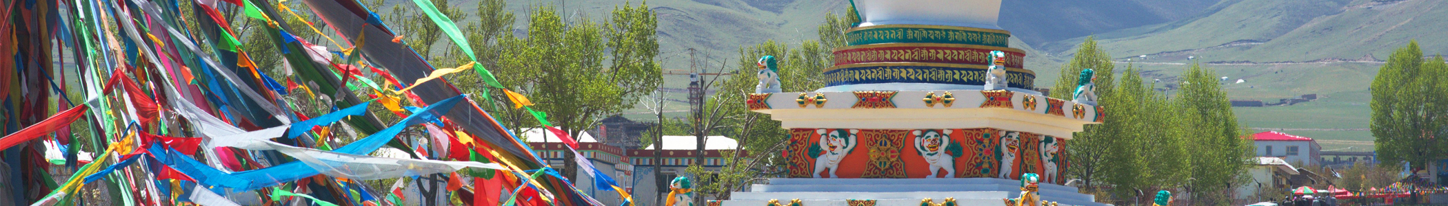
- 塔尔寺 (中文称Ta'er Si) – 这个著名的藏传佛教寺院是著名佛教改革家宗喀巴的出生地。塔尔寺有650多名僧侣。
- 第十四世达赖喇嘛的出生地 – 现任达赖喇嘛出生在青海,靠近西宁。他的出生地被认为是藏族人民的圣地。
- 湄公河、黄河和长江的源头 – 这三条河流的起点都在青海。
- 互助县的北山公园 – 这个大型公园被森林和河流环绕,是徒步旅行或露营的好去处。
- 坎布拉国家森林公园,距离西宁约2-3小时车程。240元的门票包括公园内的巴士和游览风景优美的李家峡水库的船票。也称为扎坎布拉或喀木拉。
- 青海可可西里,位于青海西北部的高原,是世界上最大的高原,也是一个世界遗产
行程
[]- With a week to 10 days, it's possible to make a loop from 西宁 or 兰州 that hits several important sites. Start in Xining. Take a minibus outside of town to the Ta'er Si Monastery, a Yellow Hat Tibetan temple where that celebrates the first Dalai Lama. Head back to Xining and catch one of the hourly buses to a small town Tongren (a 4-hour trip), where Tus have painted elaborate Thangka paintings for several centuries. From there head on to 夏河, just over the border in 甘肃 province. The three-hour drive passes 4,000-metre (13,000 ft) peaks and small Tibetan settlements. Xiahe's Labrang Monastery is the Yellow Hat's most important outside of 拉萨. Plan to spend a couple of days wandering through the temple and surrounding hills before taking the 6:30AM bus to 兰州 with a large 回族 population and cool scenery along the Yellow River. More than a dozen buses make the three-hour trip back to 西宁 every day, along with about a half dozen trains.
- If your focus is more on natural scenery, with a lesser interest in temples and no desire to spend every night in Xining, it is possible to hit virtually every major scenic area short of Dunhuang in 5 days. Charter a private car and driver out of Xining (¥550/day is a fair rate as of July 2013), and your driver can make a grand loop of the Gansu-Qinghai area. First, stay a night at Zhangye's Danxia mountains--on the way, there are at least three scenic overlooks that provide sweeping views of Qinghai's verdant valleys. Then, head toward Ox-Heart Mountain (dubbed "the Chinese mini-Alps", and rightly so). On the way, you'll pass several ancient temples, and scenery that would not look out of place on the Scottish highlands. Then, spend a few hours driving through alpine, permafrost scenery as you wind your way above 4,500 m (14,800 ft). Then, you'll wind your way to lower altitudes, heading towards Qinghai Lakes. Along the way, you'll pass through the massive Qinghai grasslands, which will take half a day (especially when you stop for scenic photo ops). Dominated by Tibetan yak and sheep herders, the grasslands stretch as far as the eye can see (and then some), encompassing lush rolling hills, winding tributaries, and probably the occasional burst of rainfall. At Qinghai Lake, stay the night on the west side of the lake, and at dawn, watch the sun rise directly from the lake itself. Bicycles are available for rent essentially everywhere on the lake. Then, drive a few hours to Gui De, which is at the origin of the Yellow River. Here, the Yellow River is a turquoise-green hue, and the geology is much like that along the US's Colorado River. Heading out from Gui De, take the rear entrance into Kambula National Geopark, and enjoy the spectacular scenery. On your way back to Xining, stop at Ta'ersi Monastery, and walk through a practicing Tibetan temple that dates back 600 years. Finally, arrive back at Xining, and enjoy a couple of bowls of niangpi from a tiny mom-and-pop noodle shop. Add a day to the itinerary if you want to visit Chaka Lake.
活动
[]- 漂流长江和黄河 – 两条河流都有适合白浪漂流和悠闲漂流的河段。
- 登山 – 有16座山峰对非中国人开放攀登。
- 农历六月初六歌咏节 – 青海各地举行,由土族、回族、撒拉族和汉族民歌手进行歌唱比赛。
购物
[]餐饮
[]- 羊肉串 – 孜然和辣椒调味的烤羊肉串是青海流行的街头食品。
- 牛肉拉面 – 手工牛肉面汤清味美,通常配有牛肉片、辣椒油和香菜。
饮品
[]- 酥油茶 – 是一种传统的藏族饮品,由牦牛油、茶叶和盐制成。通常在黄南和玉树等藏族地区饮用,通常温热饮用。
- 青稞酒 – 由大麦制成的一种温和的酒精饮料。常在藏族节日和家庭聚会时饮用。
- 牦牛奶饮品 – 在市场和当地咖啡馆都有售,有时会加糖或发酵。适合品尝当地乳制品。
注意安全
[]- 青海省冬季气候严酷。省内大部分地区是高寒、无树的草原。不要独自偏离常规路线。携带保暖衣物和额外的食物补给。一年四季都可能下雪,即使在七月,海拔4000米以上的地区夜间气温也经常降至零度以下。青海大部分地区冬季极其寒冷,夜间气温在-20°C至-30°C之间。
- 阳光在这里非常强烈。该省降雨量很少,因此晴朗的日子和缺乏遮蔽意味着很容易被晒伤。带上足够的防晒霜。戴帽子也是个好主意。
- 在徒步旅行穿越游牧地区时,要小心狗。藏獒在青海用作护卫犬,会攻击任何它们不熟悉的人。这些狗体型相当大,通常重达60公斤以上。
- 高山反应是青海的一个现实问题,因为省内大部分地区海拔超过3000米。在前往高海拔地区之前,给自己足够的时间适应。尽量缓慢上升。
下一站
[]青藏铁路于2006年7月通车。所有前往拉萨的火车都经过西宁,使该市成为前往拉萨的门户。从西宁购买前往拉萨的火车票比在成都、北京、上海和广州等大城市更容易。从西宁到拉萨的火车行程略超过24小时。
所有前往西藏的外国人都必须持有入藏批准函。前往拉萨的批准函可以在大城市(如北京、上海、成都、重庆)以及青海省西宁或格尔木的旅行社轻松办理。据报道,在格尔木,那里的旅行社收取更高的批准函费用。